Skip to content

Cookies 🍪

This site uses cookies that need consent.

Learn more

Zur Powderguide-Startseite Zur Powderguide-Startseite

Language selection

Search PowderGuide

WeatherBlogs

WeatherBlog 5 2018/19 | Review & outlook

Marilou, the northern depression

by Lea Hartl 12/12/2018
While the weekend was still characterized by mild westerly weather (which is not bad for higher altitudes), low pressure system Marilou took over from the north at the beginning of the week and gave the entire northern slope of the Alps a pretty white dress.

Status report

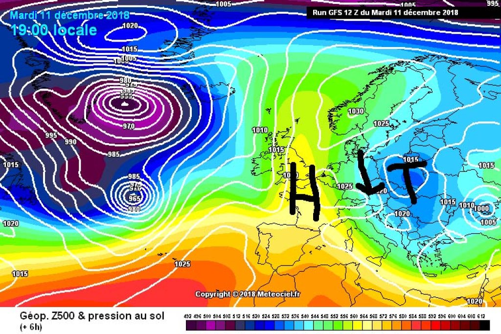
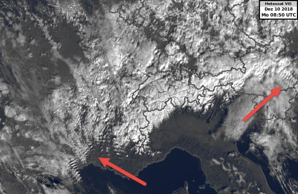
The northern storm (long awaited, much desired) has largely delivered what the weather models and internet hype promised in advance and has kept pretty much to the forecasts in terms of the amount of fresh snow and the focus of precipitation. As early as Monday, Marilou was gradually pushed eastwards by a strengthening high over Spain and the French Atlantic coast, so that the focus of precipitation also shifted further and further east.

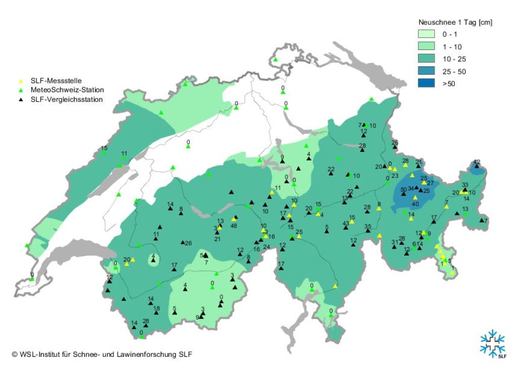
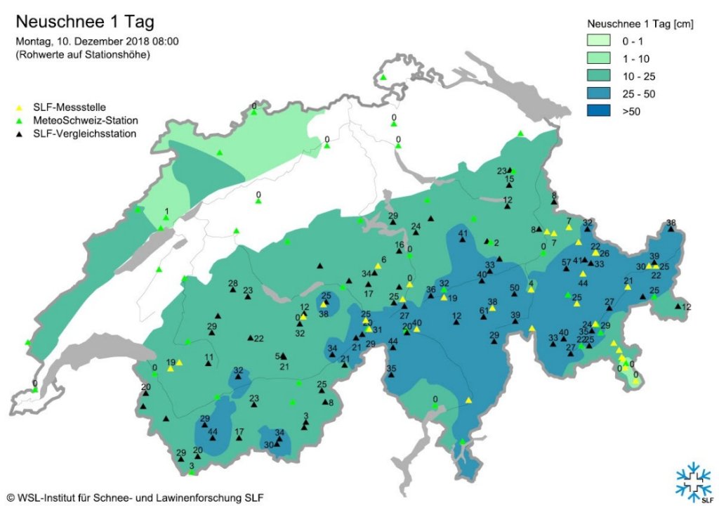
The SLF reports "widespread 80 to 150 cm" of snow above 1800m on the northern slopes of the Alps, in Valais, the Gotthard region and northern Graubünden for the period Friday to Tuesday. snow. While the precipitation in the western Alps was already subsiding on Monday, there was still up to half a meter of fresh snow in the Glarus Alps (eastern Switzerland) from Monday afternoon to Tuesday.

WeatherBlogs
presented by

In the Austrian Northern Alps, amounts of fresh snow in the high double-digit range fell at higher altitudes up to Tuesday, and in the typical north-west congested areas, the meter was cracked here and there.

The whole thing was accompanied by strong winds and a correspondingly high risk of avalanches at times. Thanks to the rather unstable atmospheric stratification in many places, there was also frequent sleet and even hail showers. In the southern Alps, meanwhile, there was quite sunny, calm northern foehn weather, clearly visible in the two-part satellite image from Monday (can be seen in the gallery below, taken from the interesting Monday MeteoSwiss blog post).

Current situation and outlook

Marilou has now more or less left the eastern Alps behind and is now turning its attention to the Balkans. Things have calmed down here and today, Wednesday, would probably be a good day to enjoy the fresh snow in sunshine and low temperatures in the entire northern Alps, with all due caution regarding avalanche risk and lack of base.

From tomorrow, it will be a little more unstable in the south, with a few flakes falling here and there and clouds clouding the otherwise predominant sunshine. Similar on Friday: widespread sunny, cold winter weather, tending to be sunnier in the north, somewhat cloudier in the south and southeast. From today's perspective, sunshine and rising temperatures on Saturday, with the next disturbance approaching from the west, which will probably cause stormy conditions everywhere on Sunday.

Large-scale, the westerly weather will stay with us for the time being. The WeatherBlog is looking forward to further clashes between Atlantic low pressure and the continental high!

Photo gallery

This article has been automatically translated by DeepL with subsequent editing. If you notice any spelling or grammatical errors or if the translation has lost its meaning, please write an e-mail to the editors.

Show original (German)

Related articles

Comments

WeatherBlogs
presented by