Skip to content

Cookies 🍪

This site uses cookies that need consent.

Learn more

Zur Powderguide-Startseite Zur Powderguide-Startseite

Language selection

Search PowderGuide

PowderAlerts

PowderAlert 2 2018/19 | Ullr's Judgement day

Ullr is back and brings classic northwest jam action

by Lars Oelmann 12/07/2018
Just like in Terminator 2, Ullr is not letting his hair down and is finally spreading powder with a coarse trowel in the Northern Alps. As in the movie, the number of explosions is likely to be quite high in this alert due to the avalanche blasts: the SLF expects "very large avalanches", which should of course keep the fun to a minimum for a few days. More on this in the alert.

In a post-nuclear future, winter will last forever and the few remaining freeriders will be hunted mercilessly by the T800, so let's enjoy this alarm while we still can!

Seriously, Ullr has finally seen sense and is allowing winter to begin on a large scale in the northern Alps. The problem with the coming large amounts of snow is the base and the massive storm that accompanies it. Tonight, the first front of Ullrnet will be sent through the powder machine and it will hardly stop until Tuesday. Tomorrow there will be smaller breaks and from Sunday it will really get going.

Alert period and areas

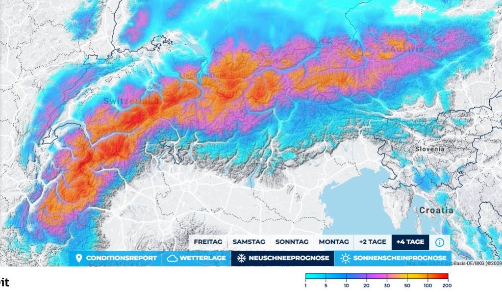
This alert applies from northern France to the Dachstein, with the core - as always in the west to northwest - from northern France to the Arlberg.

This alert applies until midday on Tuesday, as the forecast consistency is quite reliable.

Wind

There will be massive storms, so there won't be much going on at the top. From Monday, the wind will die down, which should make the last 20-40cm a bit fluffier, maybe even further up. The avalanche danger is getting scary.

The good thing is that there will be full amounts deep into Valais and along the main Alpine ridge. There should even be enough to just south of the main ridge for alerts.

Snowfall line

The whole thing starts with a cold front and quite nice snowfall lines of around 1000m, which then rise to 1200-1800m by Sunday, depending on how inner-Alpine and westerly. The further east and north, the cooler, but it may also snow in the Goms, Valais and parts of the northern Gadin, depending on the intensity, right down into the valleys.

From Sunday, the snow line will drop back below 1000m and on Monday right down into the valleys.

The full amounts will be available from around 1400-1800m, but there should also be some at 800-1000m.

The amounts

Ullr is not letting itself down and is giving its A2 Powminator enough firepower. Above 1800m there is 80-110cm of fresh snow from northern France to the Arlberg and 120-150cm in congested areas. I don't think there will be any upward surprises, as the whole thing will turn out to be less of a traffic jam from model run to model run and the high will close earlier and earlier on Tuesday.

Because the precipitation will fall over 4 days and the snow will settle, the snow cover will not increase by the amount of fresh snow. Due to the cool temperatures, however, it could be close.

At 800-1000m, there will still be good amounts of alpine meadows of 40-70cm.

East of the Arlberg, there will be 40-80cm and possibly a snow hole here and there on the meter.

Where should I go?

Phew, that's not easy and unfortunately not very weekend warrior friendly, because it doesn't really start until Sunday. You can safely wait at home on Saturday and the greedy ones can take a look at the meadow in a higher forest aisle on Sunday. But as the dump only really has juice there during the day, it will be a game of chance. Monday and Tuesday you can certainly have fun on open meadows between the trees, but whether you really want to get into the trees on Tuesday is up to you and your rock skis.

Wednesday the sun comes out and you can venture up very carefully, but it's probably more dangerous than a T1000. The days after that, you have to see how quickly the fresh snow settles and whether you can attempt a tour.

If you want powder and can take a vacation, I recommend not heading to the mountains until Monday.

Mid-term

Difficult to say. It will probably be wet again from Friday, but whether it will be warm and wet and nasty, or another powder weekend for the non-students, is still unclear, as the warmth will be quite close to the Alps and small-scale circulation changes can make a big difference. So: stock your Ullr shrine and, like John Connor, follow the WeatherBlog and PowderAlert on this website.

Powder to the People!

Your Oracle

This article has been automatically translated by DeepL with subsequent editing. If you notice any spelling or grammatical errors or if the translation has lost its meaning, please write an e-mail to the editors.

Show original (German)

Related articles

Comments