Skip to content

Cookies 🍪

This site uses cookies that need consent.

Learn more

Zur Powderguide-Startseite Zur Powderguide-Startseite

Language selection

Search PowderGuide

WeatherBlogs

WeatherBlog 11 2016/17 | Sea Effect and the outlook

The next snowy phase is just around the corner

by Lea Hartl 01/10/2017
The intermediate high influence of the last few days is coming to an end. A warm front will reach the northern side of the Alps from the west during the course of Wednesday. This will be accompanied by milder temperatures, fresh snow and lots of wind. This week in the WeatherBlog: More details on the outlook for the coming days and the sea effect snow in south-eastern Europe.

Current situation and outlook

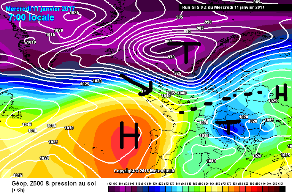
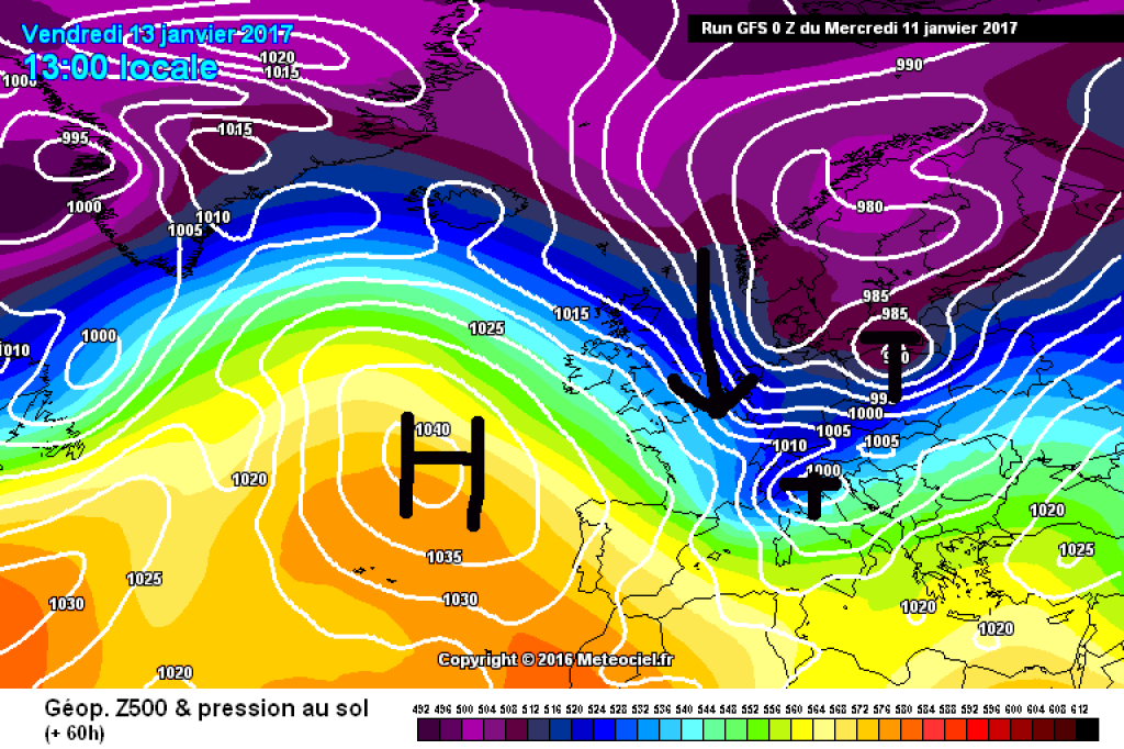
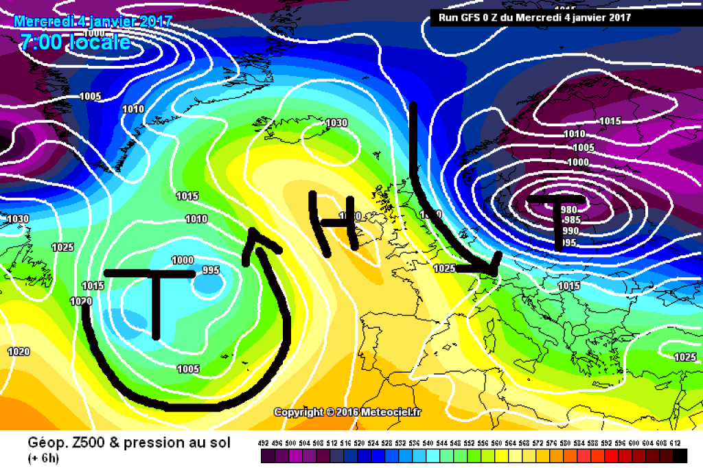
The Azores High and a low over Scandinavia are currently responsible for the Alpine weather. In the south-east, a dripping low is still involved but is gradually disappearing. The north-westerly flow between the Azores high and the Scandinavian low will become stronger and bring a load of mild Atlantic air as well as the warm front mentioned at the beginning. Temperatures are already rising at high altitudes and the cold air should soon be cleared out of many valleys. The low pressure system over Scandinavia will then move a little to the south, bringing cold air from the north, which will then reach the Alps with a cold front on Friday night. After the brief, milder interlude on Wednesday and Thursday, temperatures will be deep winter again, although not quite as arctic as recently.

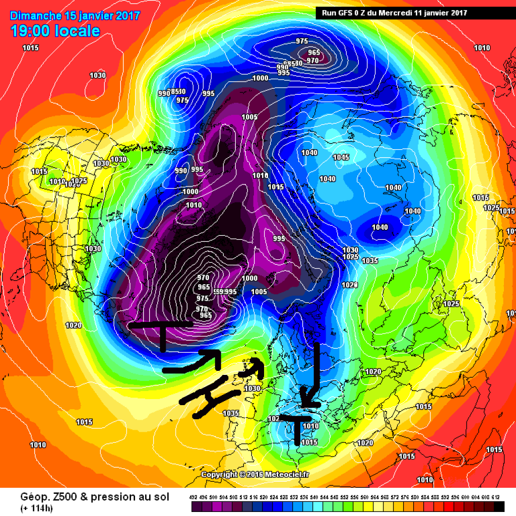
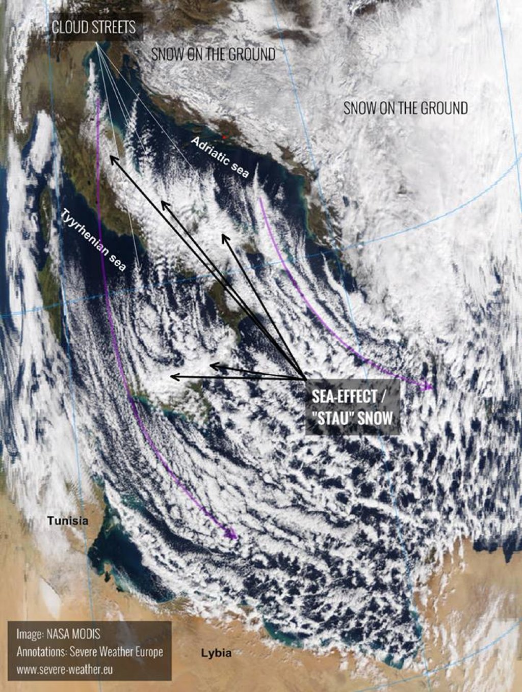
The cold high-altitude air that reaches the Mediterranean region will cause cyclogenesis (development of low pressure) there, meaning that it is also likely to snow a little on the southern side of the Eastern Alps on Friday and Saturday. In any case, the northern Alps are likely to see alarming amounts of snow by Saturday (in the south-east, everything is still on very shaky ground). We are eagerly awaiting detailed reports from the oracle.

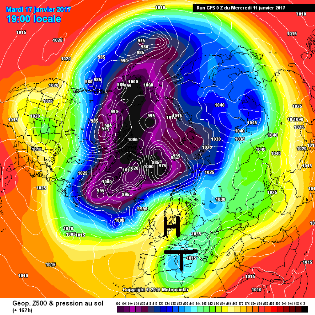
A strong low will form in the area of Greenland at the beginning of next week, causing the Azores High to tilt to the east. A high wedge will move over Scandinavia. On its eastern side, cold air is transported into the eastern Alps. In the middle of the week, a high-over-low situation will develop: The high comes to rest north of the Mediterranean low.

WeatherBlogs
presented by

Sea Effect snow in south-eastern Europe

Since our colleague Orakel is reliably dealing with snow in the Alps, let's turn our attention to the south, where there has been a lot of very vivid Sea Effect snow in the last few days. Sea or ocean effect snow is the same as lake effect snow, but in a big way. The best-known lake and sea effect hotspots are probably the Great Lakes region in the USA (unfortunately there is no suitable ski terrain here) and Japan, which owes its legendary powder masses in large part to the sea effect. In the Alps, the lake effect occasionally occurs at Lake Constance, but here the inflow has to be just right, otherwise the overflowing air masses don't have enough time to soak up moisture over the relatively small lake.
Basically, you can imagine the lake/sea effect exactly like this: Cold air flows over warm water and absorbs moisture in the process. At some point, this becomes precipitation, preferably when the moist air behind the water meets land (or even a mountain range).

Then there are a few subtleties to consider in detail. The larger the area of water that is flooded, the more moisture is carried along. The wind shear and the synoptic position must be right and, most importantly, the temperature difference between the water and the incoming air must be as high as possible to ensure abundant lake effect precipitation. The greater this difference (warm at the bottom, cold at the top), the more unstable the atmospheric stratification (compare: inversion - cold at the bottom, warm at the top - is very stable), the better the transport of energy and moisture upwards works and the stronger the convective processes become. The cold Arctic air of the last few days, bundled in the dripping low over the Aegean, paired with the warm Mediterranean water therefore created the best conditions for a pronounced sea effect.

Beautiful collections of images of snow masses in Turkey, on Greek islands and on Mediterranean beaches can be found here and here.

Photo gallery

This article has been automatically translated by DeepL with subsequent editing. If you notice any spelling or grammatical errors or if the translation has lost its meaning, please write an e-mail to the editors.

Show original (German)

Related articles

Comments

WeatherBlogs
presented by