Skip to content

Cookies 🍪

This site uses cookies that need consent.

Learn more

Zur Powderguide-Startseite Zur Powderguide-Startseite

Language selection

Search PowderGuide

WeatherBlogs

WeatherBlog 16 2020/21 | Weather conditions and climate change

What happens to the weather when the climate changes?

by Lea Hartl 03/03/2021
Last week, the WeatherBlog received the following user question: "How are weather patterns and global warming connected? Does the frequency of warm weather increase in times of global warming? Or has the frequency of different weather conditions remained the same, but they have all become warmer?"

These and similar questions always seem to come up more often when there is no change in the weather and it is warm and sunny for weeks on end. So let's take a closer look this week!

The jet stream and the weather

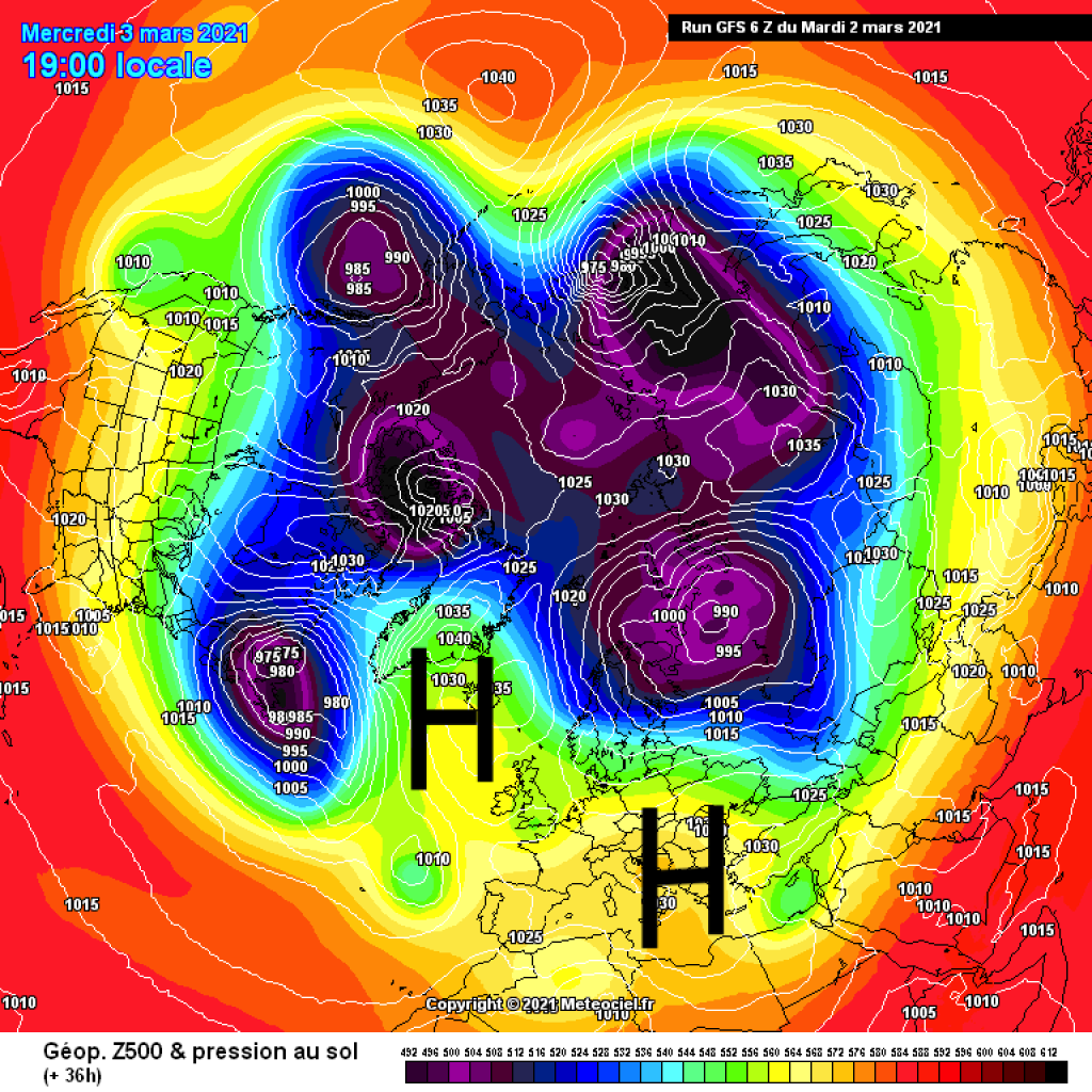
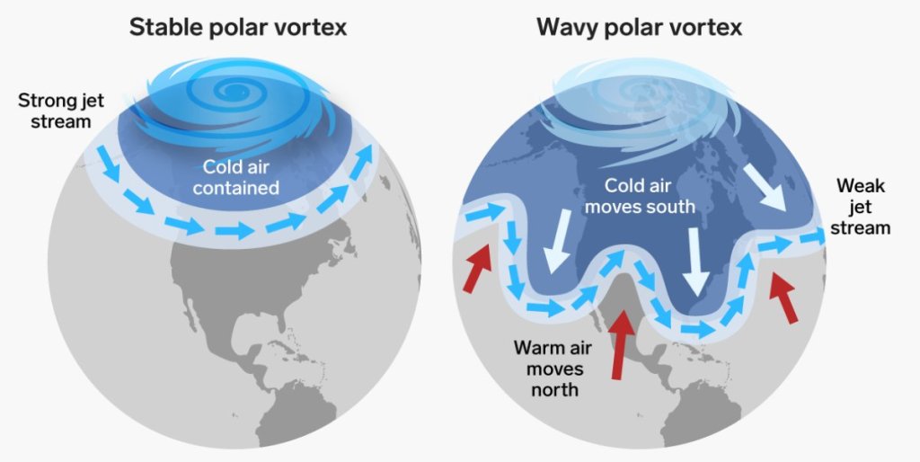
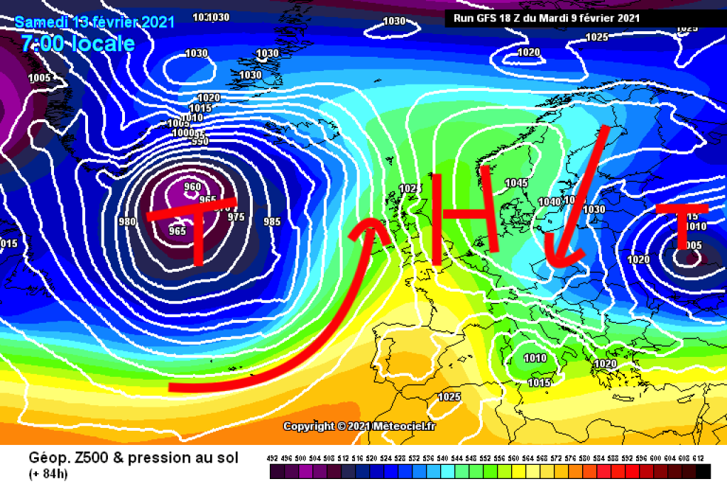
First of all, it should probably be noted that the latest round of media discussions on the subject did not arise because it was warm and sunny. Quite the opposite: the extreme onset of winter in the USA, which led to far-reaching, catastrophic supply problems (electricity, water), especially in Texas, was also often linked to global warming and changes in the jet stream. In a nutshell, the logic works as follows: As the Arctic is significantly colder than the mid-latitudes, a prominent air mass boundary is created in between, where the jet stream, which is very important for our weather, forms. Climate warming is progressing faster in the Arctic than in the mid-latitudes (Arctic amplification). As a result, the temperature difference between high and middle latitudes is becoming smaller. As a result, the polar vortex could become weaker and the jet stream could "wobble" more often in large, north-south oriented waves instead of forming a zonal (west-east) band around a round polar vortex.

We already had some of these wobbling, long-lasting weather patterns in the winter of 20/21. It doesn't have to be warm and sunny like it is at the moment - after all, every wave crest also has a wave trough, see the events in Texas, or the cold spell in Central Europe a few weeks ago. What meriodional, "blocking" weather patterns have in common is that they hardly change over longer periods of time. In classic westerly weather, on the other hand, the jet stream over the Atlantic is strongly zonal and brings new disturbances in comparatively rapid succession, alternating with short periods of high pressure. The winter of 19/20 was rather zonal, with a very strong, round polar vortex over long periods and a very mild, changeable mountain winter, as well as longer sunny periods in which the jet stream blew strongly but was clearly north of the Alpine region.

So we see: mild weather conditions can be both zonal and meridional. Meridional weather patterns (wobbling jet stream) can be very warm or very cold, depending on the exact position of the wave. If the polar vortex becomes weaker and the jet stream wobbles more often, it is to be expected that such meridional, warm or cold conditions will occur more frequently.

WeatherBlogs
presented by

Is the jet stream really changing?

This is a thoroughly conclusive theory that can be used to indirectly attribute many weather patterns to climate change. From around the mid-1980s to around 2010, a fairly significant increase in meridional weather patterns can be seen in the corresponding data. This change in the observed data naturally wanted to be explained and was decisive for much of the research currently taking place in this area. However, the observed trend does not really seem to have continued over the past decade. Moreover, 20 to 30 years is borderline short for analyzing climate change. The data situation is therefore somewhat spongy: We see a certain signal, which no one disputes, but whether it is a systemic change or natural variability (the "randomness" of the weather) is not clear.

If you want to understand the processes underlying the observed data, mathematical models are the tool of choice. We know the initial situation and we know the equations that the atmosphere obeys. This allows us to use global climate models to calculate what happens when the Arctic gets warmer. These models now work quite well and we can reasonably expect that they would see the impact of warming in the Arctic on mid-latitude weather, if it happens as we have predicted. However, different model studies come to different conclusions in this respect. Some do not see anything beyond the expected variability, while others do, especially in summer. So far, there have been few studies specifically on this issue in which the processes of the atmosphere are linked in detail to those of the oceans, which would be particularly interesting with regard to sea ice. The role of the stratosphere (above the troposphere, where our weather takes place) is also still unclear.

In English, there is the apt saying: "Absence of evidence is not evidence of absence" - roughly: a lack of evidence for the existence of something is not evidence that it does not exist. This summarizes the topic of Arctic jet stream weather in Central Europe quite well. Perhaps the connection is there, but if so, we don't yet see it clearly enough to be sure.

In the context of climate change risk and adaptation measures, there is of course a big difference between not knowing the changes and knowing that nothing is changing (comprehensive Twitter thread). Accordingly, scientists are currently working quite intensively on this topic. Ideas are being developed, tested and, if necessary, discarded. The latter does not mean that anyone has done anything wrong - that is part of the scientific process.

Further reading (studies in English):

Observed changes in recent years: No clear trend.

Cold winters in Europe more likely the result of variability, not changing dynamics

Models disagree on frequency of persistent weather patterns

Changes may be more pronounced in summer?

Drought and extreme precipitation more frequent

The situation is somewhat clearer when it comes to other weather changes: Heatwaves and drought are on the rise, especially in regions that have always tended to be hot and dry. Heavy precipitation is also tending to occur more frequently. And of course: it is generally getting warmer. How quickly and how much varies depending on the region and time of year. A correlation with altitude is likely (Elevation Dependent Warming), but this is another area with greater uncertainties.

Let's get back to the initial questions: Are mild weather conditions generally becoming more frequent, or are all weather conditions just becoming milder? We don't really know the former, but the latter is generally true.

And the weather

The uninterrupted sunshine is coming to an end. Not much will happen on Thursday, but a cold front will approach from the NW, reaching the Alps on Friday night and bringing a little snow in the north. The precipitation will probably subside by midday and it will quickly clear up again, albeit with cooler, "seasonal" temperatures and occasional clouds or even a few showers. Anyone who is already tempted to plant their garden should wait a little longer...

This article has been automatically translated by DeepL with subsequent editing. If you notice any spelling or grammatical errors or if the translation has lost its meaning, please write an e-mail to the editors.

Show original (German)

Related articles

Comments

WeatherBlogs
presented by