Skip to content

Cookies 🍪

This site uses cookies that need consent.

Learn more

Zur Powderguide-Startseite Zur Powderguide-Startseite

Language selection

Search PowderGuide

PowderAlerts

PowderAlert 4 2022 /23 | On the hunt for the average

It's snowing! There is already a base below 2000m! Powder?

by Lars Oelmann 01/14/2023
In this alarm you can almost finally ski like in a normal season! Joy! The only downside: unfortunately only in Lower Valais and France.

Otherwise, you have to keep waiting in the Eastern Alps and play November. In the whole of the Eastern Alps? No, a small Gallic village in the IT/AT/SLO border triangle is putting up fierce resistance here too and will probably get snow again.

Tomorrow, it's going to kick off right away with a cold front that will put an end to the current Glop™, but won't really snow until the afternoon. But more on that under "where should I go?"

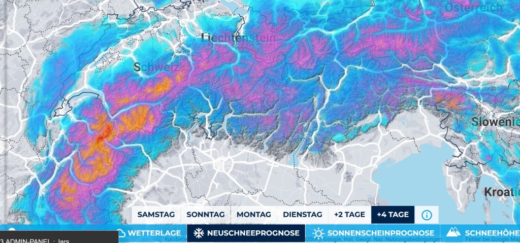
Alert period and areas

The alert lasts until Tuesday morning, when there should be a short break. After that, it is still extremely uncertain.

The alert extends from the lower Valais to France and in the south-east to the border triangle.

In northern Switzerland from the Bernese Oberland to the Arlberg, it will snow around the alert amounts, but spread over three days will not provide powder fun anywhere.

Wind

Won't be too wild. The worst is behind us and after the cold front, that's okay. As it passes through, however, it will get rough on Sunday. It also pushes well into France, less so in Valais due to the direction.

Snowfall line

From 1700m to the very bottom (well 600-900m). Finally powder and it stays cold and doesn't suddenly go up again on Tuesday.

The amounts

From the northern Valais to the Hautes Alpes there will be 40-70cm and in the backwaters about 60-90cm. Whether the meter will be full here and there is still unclear, as the models for Monday Tuesday still show a decent spread because there is a marginal low moving around.

In the southeast, there are narrowly limited 50-80cm in the border area IT/SLO. Whether Carinthia will still be affected is unclear. But it should also be enough for alerts in the border triangle.

Where should I go?

That's difficult. Sunday morning is not going to be a good day for deep instagram shots because it's still quite warm. In the late morning, the whole thing comes down with a bang and there's already a good 20-30cm by the afternoon. In France and on the border on the Swiss side, it could be as much as 40 cm.

So, the oracle would look for tall trees there and wait and see. At best, you know how much of the base was below 2000m beforehand.

On Monday it will continue to snow and on Tuesday it will clear up so that you can go higher. There may be some snow again on Tuesday afternoon, but that is still uncertain. Nobody knows whether it will be an alarm.

After that, it will remain cold, but not completely trouble-free, so you should pay attention to visibility when planning your tour and possibly avoid long, flat glacier plateaus if you don't want to practice with a map and compass.

Mid-term

The snow will hold off until the weekend and even the weekend warriors can still find powder in the west, even if not from the lift. After that, it's more likely to be the end of precipitation, but at least it won't be warm.

Snow depth prediction game

The snow depth prediction game will take place at the "Ecreuleuse (2252m)" station from 14.1. to 17.1. 10:00am: Post your tip in the PowderGuide-Forum -> Sweepstakes !

Powder to the people!

Your Oracle

This article has been automatically translated by DeepL with subsequent editing. If you notice any spelling or grammatical errors or if the translation has lost its meaning, please write an e-mail to the editors.

Show original (German)

Comments