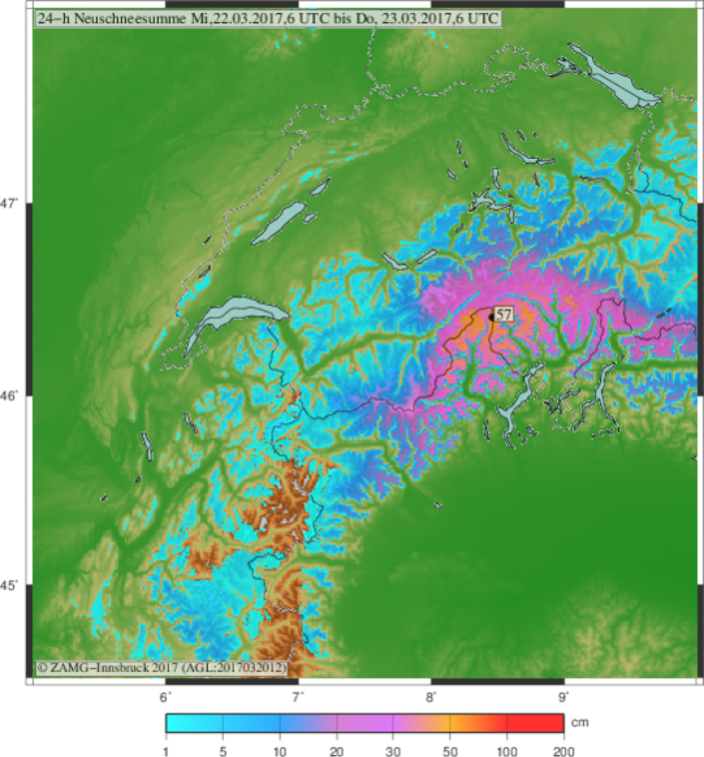
Skip to content

Cookies 🍪

This site uses cookies that need consent.

Learn more

Zur Powderguide-Startseite Zur Powderguide-Startseite

Language selection

Search PowderGuide

PowderAlerts

PowderAlert 18.1 2016/17 | Long-lasting snowfall in the south

It starts and snows until the weekend

by Lars Oelmann 03/20/2017
This alert will probably be published in two parts, but then I'm in the best Belltristik and Hollywood company, because like Twilight and Harry Potter, at the end of this winter there's a story by Ullr, our favorite author and Powder screenwriter, that can't be squeezed into a single film or alert. And as with those movies, we at PowderGuide hope you'll be eager to read the second installment and pour hundreds of millions of euros into our coffers!

Areas and period:

This alert is valid until Thursday evening and then alert 18.2 should appear, as it should continue to snow continuously in the south. Only where is not quite clear yet.

The area until Thursday evening goes from the Grand Paradiso massif to the Upper Engadine / Adamello and the core is, as so often, in the Monte Rosa / Simplon / Ticino triangle.

Snow line:

The snow line is likely to be around 1300m in the core with heavy precipitation in some valleys and around 1900m in the peripheral areas with light precipitation on Wednesday.

Fluffy powder with a guarantee will probably only be available above 1800-2000m, as the zero degree line is likely to be around there.

Wind:

Surprisingly tame for the amounts! Even at 3000m there are hardly any strong winds or storms and the wind-protected areas should remain quite fluffy, even at the top. Since the base and the old snow problem in parts of the south (e.g. in Ticino) isn't that scary or hardly exists at all, that's good news for the days to come.

The amounts:

By Thursday evening, 30-60cm will fall from Gran Paradiso to the Upper Engadine, from the eastern and western edge to the core.

In the core from Ticino to Monte Rosa it will be 60-80cm and in potholes probably 1m here and there, above 2000m.

Where to go:

Throughout the alert in the trees of the south. I would stay above 1600-1700m in the core to have fun.

Mid-term:

It continues to snow. In the second alarm from Thursday to Saturday there will be some more, with the focus probably shifting towards the Italian-French border area. But it's not all over yet on Monte Rosa and in Ticino either. It's hard to say how much will come, but there could be up to a meter or more, albeit possibly in other regions. After that, the crystal ball sees a break in Ullr's work towards Saturday, but what happens then is open.

Due to the settling, I hardly see snowpack gains of more than 90-110cm in three days, even if there may be 150cm or more as a total. (EVENTUALLY!)

Powder to the people!

Your oracle.

Here's the prediction game!

This article has been automatically translated by DeepL with subsequent editing. If you notice any spelling or grammatical errors or if the translation has lost its meaning, please write an e-mail to the editors.

Show original (German)

Related articles

Comments