Skip to content

Cookies 🍪

This site uses cookies that need consent.

Learn more

Zur Powderguide-Startseite Zur Powderguide-Startseite

Language selection

Search PowderGuide

WeatherBlogs

WeatherBlog 1 2016/17 | Onset of winter at the weekend?

And greetings from the polar vortex

by Lea Hartl 11/01/2016
To kick off the 2016/17 WeatherBlog season, we are addressing a topical question from PG user Peleiade: "What do I need to read? The polar vortex is weakening, extreme mildness in the Aleutian Islands and there is even a threat of a polar vortex split in early November? What does that mean in terms of fresh snow?"

The WeatherBlog was rather rudely awakened from its summer slumber by the current weather situation and the things you have to read about it. Still drowsy, we took a look around to see what you need to read. Welt.de sees the cold autumn as a "bad omen" and links to a climate change skeptic blog that believes we are at the start of a new ice age and suspects that the National Snow and Ice Data Center (NSIDC) is maliciously misrepresenting sea ice area, the DWD is engaging in satire and "concealing facts", and so on. We would have liked to turn around and sleep for a while. If you want to read something else (in addition to the WeatherBlog!), WetterOnline has a useful, albeit brief, summary of the situation. For those who are serious about their interest in the polar vortex and co, this detailed explanation is recommended (rather long and complex, in English).

So what's going on?

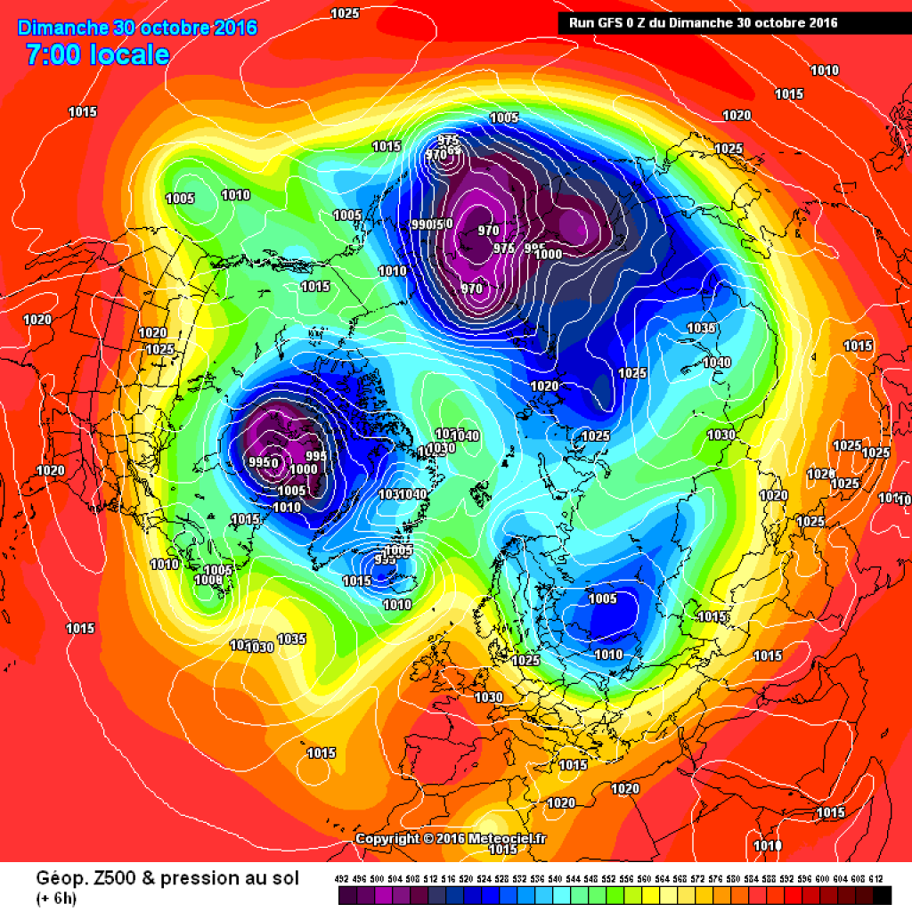
The polar vortex is indeed weakening. Low pressure centers in the area of the Aleutian Islands and west of Greenland are pumping warm air towards the pole. This has recently led to the formation of a high-pressure bridge between Alaska and Svalbard, which splits the cold polar vortex with a warm bridge over the pole. The division is no longer as pronounced as it was a few days ago, but the disrupted basic structure still exists.

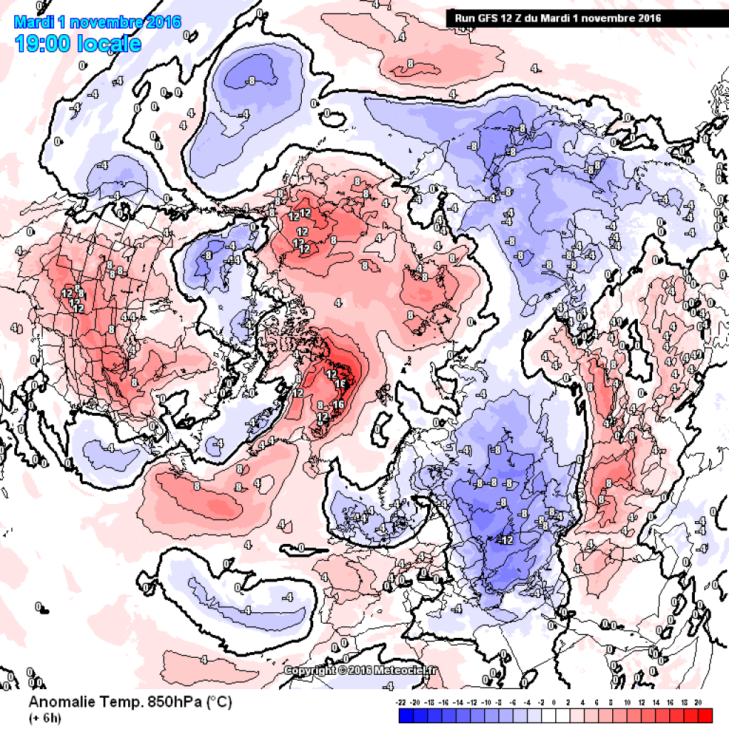
Temperature distribution in 850hPa in the northern hemisphere, reanalysis from 30.10.: High pressure bridge over the pole clearly visible.

Why is that?

Well, many people would like to know that in more detail. The pressure distribution is probably related to the sea ice, but no one can really say for sure. The extent of the Arctic sea ice in October was very small this year (the summer mininum, on the other hand, was not as extreme as in some previous years, see figure below). Due to the relatively large, warm, ice-free areas of water, there is a clear positive temperature deviation over the Arctic (figure below). The continents, on the other hand, already have a fairly extensive snow cover (Eurasian snow cover is more advanced than usual at this time of year) and are cold. This situation is also known as the WACCy pattern - Warm Arctis, Cold Continents. The more pronounced the cold air reservoir in Siberia, the more persistent it can remain there, getting in the way of the polar vortex and shoveling cold air into Central Europe during Atlantic blocks. The connection between little sea ice, warm water and relatively heavy snow and cold on the continents can be speculated about with some justification. It is repeatedly assumed (example) that little sea ice indirectly leads to more snow and colder winters (warm water evaporates, warm, moist air meets cold continent, produces precipitation there, WACCy promotes circulation disturbances, etc.).), but there are also studies that disagree and the connection has not yet been definitively and conclusively reproduced with climate models (example).

WeatherBlogs
presented by

What is happening now?

The pronounced poleward heat transport favors the propagation of planetary waves into the vertical (vertical wave activity flux), i.e. disturbances that propagate from below from the troposphere into the stratosphere. In the stratosphere, too, the polar vortex currently exhibits a bipartite structure, which usually only occurs in high winter when the stratosphere warms up. The fact that the polar vortex in all relevant atmospheric layers is so out of round so early in the season is indeed unusual and so far no one seems to be able to remember a comparable situation. As the whole thing is taking place before the radiation minimum, the sun can do little to resolve the situation quickly, as was the case with the very late split last April.

As has often been discussed in the WeatherBlog, a disrupted polar vortex is accompanied by weakened or completely stalled westerly drift. Blocking situations are becoming more frequent. If we had the current pressure distribution in high winter, a sustained period of wintry weather in Central Europe would be reasonably likely due to an Atlantic block and the icy influence of the continental east. As the whole thing is happening so early in the season, it is not really clear. There is a lack of experience to assess the situation statistically, the polar vortex could catch up again, it could not penetrate properly into the stratosphere or only last for a short time, the westerly drift could start up again. How developments in the stratosphere fundamentally affect tropospheric weather is also rather opaque. Nevertheless, the large-scale constellation certainly contains winter potential (or cold potential, precipitation is another matter) for the next few weeks and it will be interesting to see how November develops.

Concrete outlook

October, which has been quite golden recently, has come to an end. Today, Wednesday (2.11.), a cold front will reach the Alps from the northwest. The snow line will drop to around 1000m by Thursday, possibly even lower in the east. However, the precipitation will not be too heavy and will largely subside by Thursday lunchtime. From today's perspective, Friday will be somewhat sunnier again with intermediate high pressure.

The weekend will be exciting. The current will initially turn SW and it will be foehn in the north, while accumulating precipitation will set in in the south. A cold front will then approach again on Sunday. The precipitation will spread to the entire Alpine region and the snow line will drop. The models currently consider it likely that an Italian low will also develop which, in combination with cold air in the north, will ensure that the precipitation continues well into next week. In some cases, very high precipitation totals are expected within a week, especially in southern Europe (potential flooding problem). A fairly prominent air mass boundary is likely to form, which will more or less cross Switzerland and Austria and probably move slowly southwards. The exact position of the air mass boundary will determine whether it shines up to the higher valleys or whether it rains further up. In general, the development from the weekend onwards is anything but set in stone, but at least things are happening!

What the polar vortex will do with the further development, or whether it will do anything at all, remains to be seen. The Italian low and the front at the weekend are more interesting for the next few days.

This article has been automatically translated by DeepL with subsequent editing. If you notice any spelling or grammatical errors or if the translation has lost its meaning, please write an e-mail to the editors.

Show original (German)

Related articles

Comments

WeatherBlogs
presented by