Skip to content

Cookies 🍪

This site uses cookies that need consent.

Learn more

Zur Powderguide-Startseite Zur Powderguide-Startseite

Language selection

Search PowderGuide

WeatherBlogs

WeatherBlog 24 2015/16 | Weather outlook and glacier excursions

April weather and the ÖAV glacier report

by Lea Hartl 04/12/2016
Beautiful weather over the last few days has meant that the glaciers in the Eastern Alps are very busy, even though there is very little snow.

Beautiful weather over the last few days has ensured plenty of activity, although there is very little snow on the glaciers in the Eastern Alps.

LH
Stubai
After a few dry, clear days, a change in the weather is on the horizon and fans of thunder and lightning are looking forward to the start of the thunderstorm season. The medium-term outlook is uncertain, but at least there is no threat of midsummer yet. Also: The Alpine Association presents its glacier report for the 2014/15 season.

Current situation

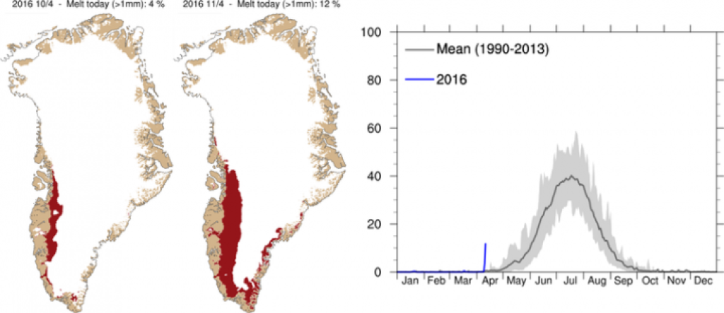
Characterizing for the general weather situation is a strong undulation of the jet over the Atlantic. While a massive trough has settled over the eastern half of Canada, a high pressure system lies downstream (to the east) of it, reaching as far north as Greenland. Again to the east of this lies an Atlantic trough, and the Alps are in its frontal SW current. The omega-like high in the area of Greenland has been there for some time now and is causing extremely high temperatures far above the usual average values at this time of year. The seasonal melting of the Greenland ice sheet has already begun - on about 12% of the ice sheet (melting has been registered especially in the southwest of the island since this week. Melting usually only begins in earnest towards the end of May.

WeatherBlogs
presented by
Ad

Outlook

The mild air masses reaching us in the SW current of the Atlantic trough will become increasingly unstable. In combination with a cold front arriving in the eastern Alps this afternoon, the weather will become unstable and wet. The front will cross the Alps from west to east, bringing heavy showers in places and possibly even the odd thunderstorm. On Thursday, the precipitation will ease from the west and the weather will clear, but it may remain rather cloudy in the east until the evening. Friday looks friendlier everywhere but not cloudless.

The further development is still rather uncertain and depends on the exact positioning of the pressure centers. The strong trough over the eastern half of North America will be increasingly pushed eastwards, which should slowly bring the unusually warm weather in Greenland to an end. The Atlantic high that has been pushed out of the north will move towards Europe, but the models do not yet know exactly where it will go. It is likely that cold air from the north will reach Central Europe on the eastern flank of the anticyclone at the weekend, while warm subtropical air will oppose it from the south. At the moment, it looks as if the weekend will be a relaxed one in the north with Föhn winds, while clouds will accumulate in the south. For the days after that, it will depend very much on where the air mass boundary finally comes to rest; it will probably continue to be relatively changeable with "normal" April temperatures.

Left: Map of areas (red) where melting is taking place, April 10 and 11. Right: Area with melting as a percentage of the total area this year (blue) and on average for the years 1990-2013 (black curve).

Left: Map of areas (red) where melting is taking place, April 10 and 11. Right: Area with melting as a percentage of the total area this year (blue) and on average for the years 1990-2013 (black curve).

www.polarportal.dk

Glacier Report Alpine Association

The Austrian Alpine Association presents its 125th Glacier Report. The article published in Bergauf can be downloaded here. Volunteers have been measuring the changes in length of numerous glacier tongues for over 100 years. The change in length is easy to measure (mark stones with paint, see how the distance between ice and stone has changed in the following year) and the admirable commitment of many long-serving helpers has resulted in valuable time series that document the fluctuations of the Alpine glaciers. Of the 92 Austrian glaciers observed in 2015, 88 (96%) have retreated, 3 have remained stationary (about half as many as in the previous year) and one has advanced slightly. The average loss in length in 2015 was -22.6 meters, with three glaciers becoming shorter by more than 100m (Hornkees, Zillertal: -136m, Gepatschferner, Ötztal: -121m, Taschachferner, Pitztal: -101m). For comparison: the Winklkees in the Hochalmspitz group, the only glacier with a positive change in length, became a moderately impressive 4.5 meters longer.

In addition, completely unrelated to the weather, the WeatherBlog was delighted to receive this news today.

This article has been automatically translated by DeepL with subsequent editing. If you notice any spelling or grammatical errors or if the translation has lost its meaning, please write an e-mail to the editors.

Show original (German)

Related articles

Comments

WeatherBlogs
presented by