Skip to content

Cookies 🍪

This site uses cookies that need consent.

Learn more

Zur Powderguide-Startseite Zur Powderguide-Startseite

Language selection

Search PowderGuide

WeatherBlogs

WeatherBlog 2 2018/19 | Föhn with fog soup

Dull early winter weather, then snow in the south

by Lea Hartl 11/21/2018
After the welcome cooling, including snowflakes in the lowlands at the start of the week, the cold air supply is now being turned off again. There is a threat of low gradient, gloomy weather with a tendency towards mild, foehn-like temperatures at high altitudes and inversion torpor in the valleys.

Current situation

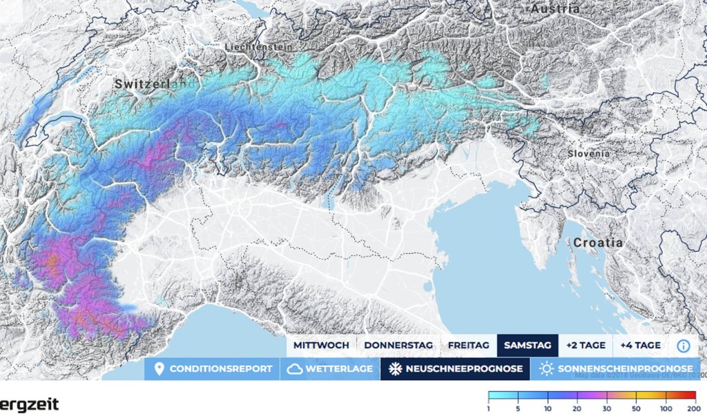
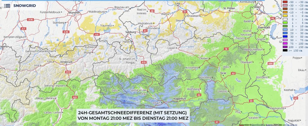
The high-over-low situation discussed last week with the extended high ("Burckhard") over Scandinavia and smaller lows moving back and forth in the Mediterranean remains essentially unchanged. Low pressure systems Dschuna in the western Mediterranean and Burkhard have produced an easterly flow over the last few days, bringing cold air into the Alpine region. Dschuna used the cold air to produce the odd snowflake or two, and there were quite a few in the Monte Rosa region and the Carnic Alps. It was even enough for a bit of winter panic and traffic problems in Vienna, but now Dschuna seems to be exhausted and is retreating westwards again, giving Burkhard the upper hand in most of the Alps.

WeatherBlogs
presented by

Outlook

With a slight southerly flow at the front of Dschuna, it will become significantly milder again over the next few days, at least above the inversion that hangs in many valleys. In the Eastern Alps, it will remain calm and relatively sunny until Friday, at least for those who make it over the inversion. Far to the west, clouds will accumulate from the south on the main ridge and it will snow a few centimetres.

In general, things will get more interesting at the weekend: With the overall situation still weak in terms of gradients and a high over northern Europe, a disturbance will push towards the Alps from the southwest on Friday afternoon, bringing snowfall from the south to the main ridge. The spectacle will spread from west to east in the course of Saturday night. Saturday will be rather cloudy everywhere, with hardly any precipitation expected north of the main ridge. On Sunday, it will gradually clear up again from the west.

Overlook

Following the early season Instagram hype, you'll know that unusually, the eastern US has probably fared the best lately in terms of winter and forest and meadow crust on the first snowfalls of the season (e.g. here). A look at the northern hemisphere maps shows us not only our well-known Scandinavian high, which forces all potential lows southwards, but also two pronounced low-pressure centers draped around it over the east of the North American continent and western Siberia. So if it doesn't really want to snow, at least in the northern Alps, you can perhaps console yourself with the thought that it is currently far too warm in otherwise extremely wintry regions such as Greenland and Alaska. Or you can simply head south on your stone skis at the weekend.

Photo gallery

This article has been automatically translated by DeepL with subsequent editing. If you notice any spelling or grammatical errors or if the translation has lost its meaning, please write an e-mail to the editors.

Show original (German)

Related articles

Comments

WeatherBlogs
presented by