Skip to content

Cookies 🍪

This site uses cookies that need consent.

Learn more

Zur Powderguide-Startseite Zur Powderguide-Startseite

Language selection

Search PowderGuide

WeatherBlogs

WeatherBlog 18 2018/19 | Short update between alerts

Rapid succession of fronts brings precipitation

by Lea Hartl 03/13/2019
On Thursday it might be wintry again briefly in the forest.

On Thursday, it may also be wintry again briefly in the forest.

LH
MO
It's going to be a turbulent week - the PowderAlert has already announced it. One front chases the next, all bringing precipitation, initially with relatively cool temperatures.

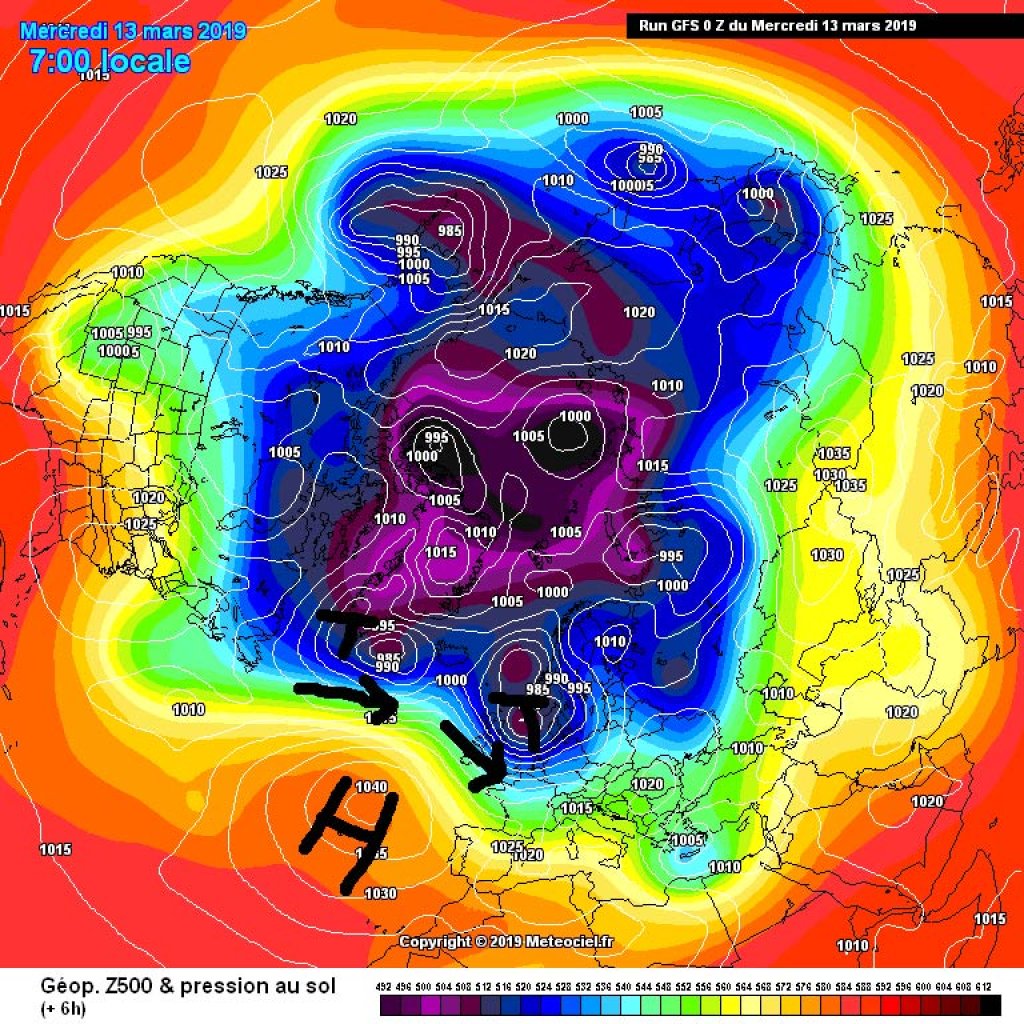
Cyclonic westerly situation develops northern component

The situation can still be summarized as "changeable westerly weather". The Atlantic frontal zone is currently battling with the Azores High. The latter is trying to extend northwards towards Iceland, where new lows from the northwest Atlantic are constantly arriving. Due to the increased activity of the Azores High, these have to take a small detour to the north before they make it to Europe and therefore arrive in the Alps from a north-westerly direction. The detour to the north allows them to collect colder air masses on the way, in contrast to the disturbances last weekend, which reached the Alps via the direct western highway without touching colder, more northerly latitudes.

WeatherBlogs
presented by

Outlook

Today, Wednesday, will bring variable clear spells and a tendency towards lingering showers, with generally more cloud in the east and sunshine south of the main ridge. A cold front will reach the Alps from the northwest in the night to Thursday. The snow line is expected to remain relatively low, especially in the east, so that one or two treerunners could possibly experience that winter feeling again. More details on this soon from the oracle, if it deems this snowfall event worthy of its attention.

On Thursday it might be wintry again briefly in the forest.

On Thursday, it may also be wintry again briefly in the forest.

LH
MO

A warm front follows immediately afterwards (night from Thursday to Friday). The precipitation will continue, but temperatures and the snow line will rise. The warming will march from west to east. It is difficult to say exactly where it will rain and how much and depends on the local topography and the exact timing of precipitation in relation to the arrival of the warmer air, but it can be assumed that the winter feeling in the forest will be gone everywhere. It can also be assumed that the combination of heavy precipitation, rising temperatures and wind will result in a very tense avalanche situation.

After the front moves away, sunny, mild weather will prevail at the weekend.

Photo gallery

This article has been automatically translated by DeepL with subsequent editing. If you notice any spelling or grammatical errors or if the translation has lost its meaning, please write an e-mail to the editors.

Show original (German)

Related articles

Comments

WeatherBlogs
presented by