Skip to content

Cookies 🍪

This site uses cookies that need consent.

Learn more

Zur Powderguide-Startseite Zur Powderguide-Startseite

Language selection

Search PowderGuide

WeatherBlogs

WeatherBlog 10 2018/19 | The calm after the storm

End of the extreme snowy weather

by Lea Hartl 01/16/2019
High pressure influence currently in the Alps and also at the WeatherBlog outside the window.

High pressure influence currently in the Alps and also at the WeatherBlog outside the window.

LH
The persistent, very heavy northern precipitation has come to an end and a high with a core in the western Mediterranean will dominate the weather in the Alpine region today, Wednesday. Over the next few days, there will be minor disturbances from time to time, but compared to the weather of the last two weeks, it will remain calm. Time to take a deep breath, dig out the cars and shovel off the roof.

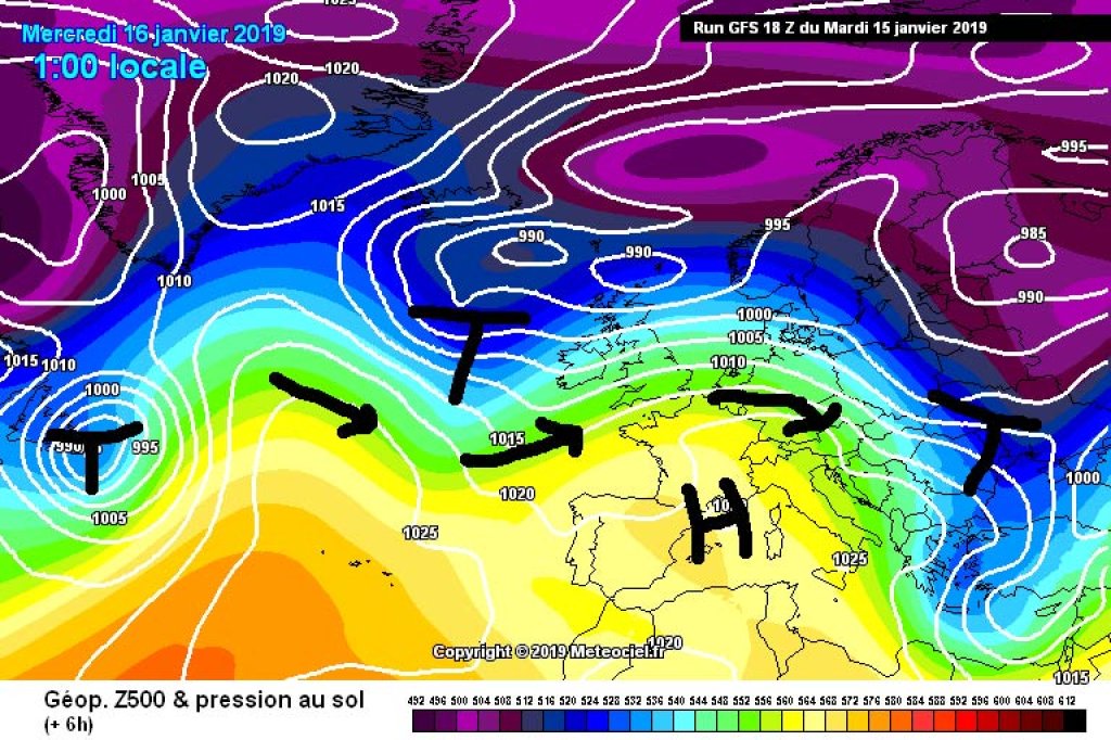
Current situation and outlook

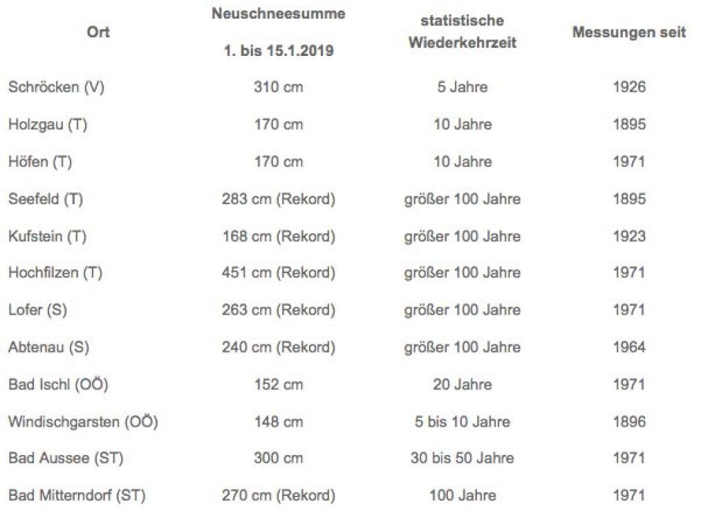
With a slight westerly flow, the sun will shine almost everywhere today, with a few high clouds here and there. It will become cloudy again during the course of Thursday and the clouds will probably build up from the morning onwards, especially on the southern side of the Alps, with precipitation gradually setting in - a long-awaited event for the south. It's tempting to describe the expected snowfall as a drop in the bucket, given that fresh snow in the north has recently been measured in meters rather than centimeters. In reality, however, we're more likely to be dealing with cold stones that are easily covered in snow.

The tendency towards changeable westerly weather will continue until the weekend. On Friday, it will probably still be quite cloudy in the east with a few snow showers, but it will clear up from the west. Then the next round of medium-range disturbances will follow as part of a rather low-grade, also medium-range low-pressure system. In other words: a mixed weekend, a few snow showers here and there and the occasional ray of sunshine, perhaps. The south-eastern Alps will benefit from fresh snow during the upcoming weather period, where the base will gradually be improved with several smaller snowfalls.

WeatherBlogs
presented by

How unusual was the north jam?

On the first sunny day, the dust is barely clearing from the blasted avalanches (we particularly recommend the, the, and the, but the internet is currently a bottomless treasure trove with heaps of spectacular videos of blasting successes of all kinds), the weather services are trying to translate "Wow, I think it's never snowed so much" into the language of statistics.

In an interesting article by ZAMG, you can find information on the annual snowfall totals since January 1st. In Seefeld, Kufstein, Hochfilzen, Lofer, Abtenau and Bad Mitterndorf, new record values were recorded, each with a statistical return period of 100 years ("century event"). The probability of such an event occurring in any given year is 0.01, or on average 10 times in 1000 years. Calculating something like this (by placing distribution functions over the longest possible measurement time series) is not only helpful for putting overly dramatic headlines into perspective, but also helps with the creation of hazard zone plans, for avalanches as well as for floods or debris flows.

High pressure influence currently in the Alps and also at the WeatherBlog outside the window.

High pressure influence currently in the Alps and also at the WeatherBlog outside the window.

LH

The topic of snow loads on roofs is also of current interest - the relevant building regulations are based on the same type of statistics. Snow loads are currently higher than usual for the time of year in many of the snowy northern regions and in some cases already exceed the standard load values.

We wish the north lots of fun in the snow (with due caution, be it on the roof or on the mountain) and keep our fingers crossed for the south that a few powder turns will finally be possible.

This article has been automatically translated by DeepL with subsequent editing. If you notice any spelling or grammatical errors or if the translation has lost its meaning, please write an e-mail to the editors.

Show original (German)

Related articles

Comments

WeatherBlogs
presented by