Skip to content

Cookies 🍪

This site uses cookies that need consent.

Learn more

Zur Powderguide-Startseite Zur Powderguide-Startseite

Language selection

Search PowderGuide

WeatherBlogs

WeatherBlog 1 | 2018/19 | When will the weather be right again?

Review, outlook, start of the season

by Lea Hartl 11/14/2018
The WeatherBlog is slowly waking up from its summer slumber, even if the current weather is rather tempting to throw the alarm clock out of the window and turn over again. After the first hopeful harbingers of winter, a tough blocking situation has dominated events for some time now. Nevertheless, the block is shifting and temperatures are dropping. And: Tomorrow, the PG Weather Service will also start the season!

Current situation

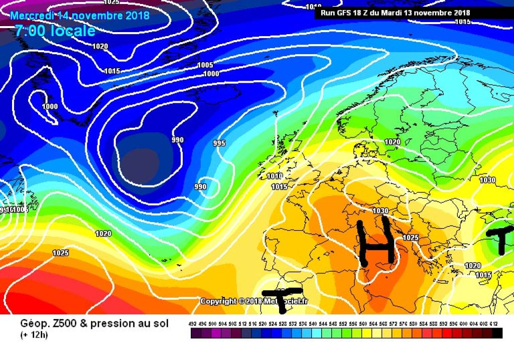
Until yesterday, the Alpine region was still in a mild SW current at the front of a low pressure system off the European Atlantic coast, which caused cloud congestion in the south and partly tough high fog, foehn and no winter feeling at all in the north. This is now slowly changing: a small offshoot of the low is drifting southwards and the rest is moving towards the Baltic States in an unexciting weather pattern.

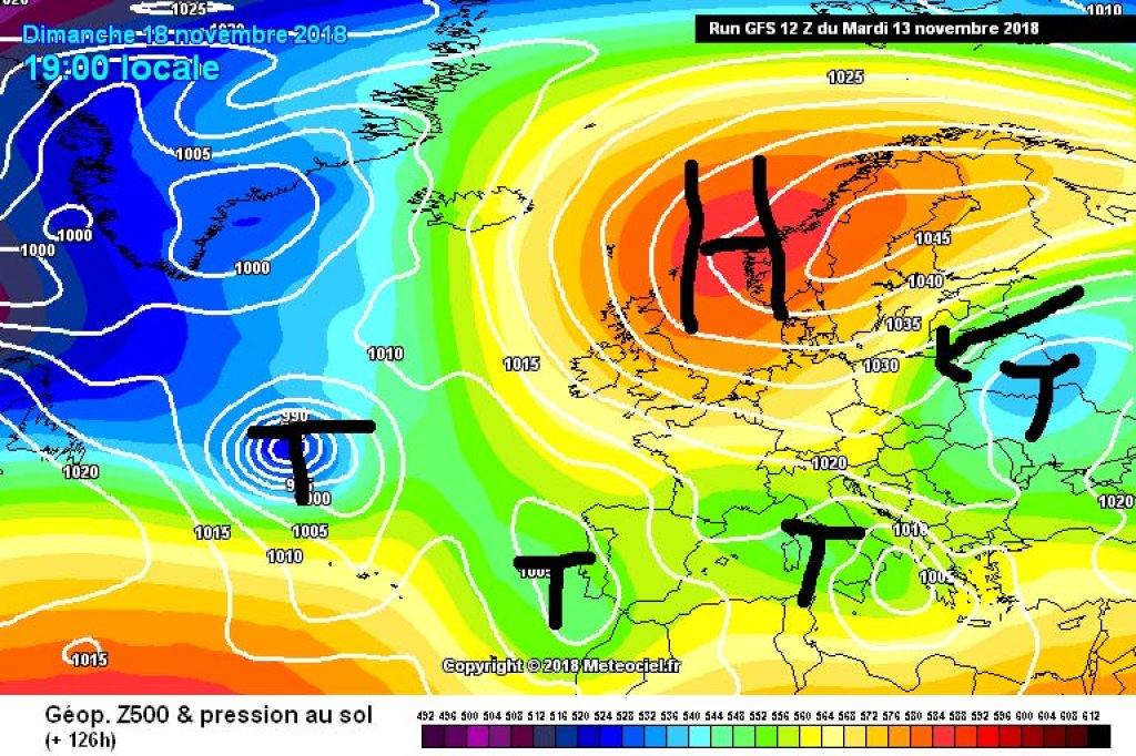
The next Atlantic low is moving into position from the west and you might think that everything will stay the same. However, even small cattle make dung and the two troughs, which are located southwest and southeast of the Alps, will push an area of high pressure between them over the next few days that will extend far into northern Central Europe. Embedded in the high-altitude current on the eastern edge of this high, the low in the south-east moves back a little in our direction and brings cold air with it. At least in the Eastern Alps, the temperature "adapts to the season", as the weather forecast always says so nicely.

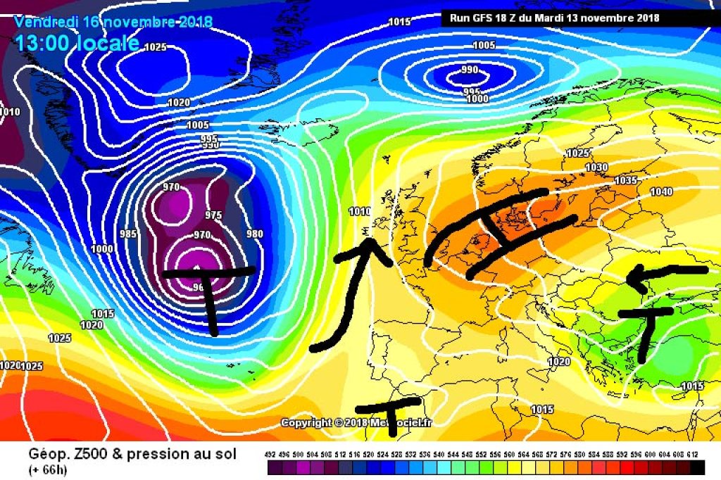
From today's perspective, we then completed the change from an Omega block to a high-over-low block at the weekend, with a sloping high over northern Estonia and Scandinavia and a low-pressure trough between the Azores and the Baltic States. Due to the easterly flow component, cold air from the east will continue to penetrate into the Alpine region and with a fresh north-easterly wind, it could become almost touchingly cold at high altitudes. Provided there is no high fog, it will remain widely sunny up to and including the weekend.

In terms of precipitation, the outlook is poor. With the arrival of the cold air masses, there may be a few flakes out of the fog at low altitudes (or perhaps from real clouds in the north-east at the weekend), but for heavy, base-forming snowfall we need the help of the Atlantic and it will remain pretty much on the sidelines for the time being due to the old, new blocking situation. Yes, sometimes the Mediterranean does it too, but even it doesn't feel inspired by this weather situation to perform at its wintry best.

WeatherBlogs
presented by

Short summer review

The summer of 2018 joins the series of very warm summers that have almost become a habit. In Austria, the deviation from the climatological average was 2 °C. Only 2003, 2015 and 2017 were warmer in the 252-year measurement history. The 2018 summer half-year (April to September) was even the warmest in recorded history. There were an unusually high number of hot days (days with a maximum temperature of over 30 °C) and generally too little precipitation, even if the snowfall at the end of August partially made up for the deficit from spring and early summer.

The statistics from Switzerland are similar: here, too, the summer temperature was 2 degrees above the climate average. This made 2018 the third warmest summer in recorded history (beginning in 1864) after 2003 and 2015. In eastern Switzerland in particular, it was extremely dry from late spring until the wet period in August. In some locations, the lack of rain during this period falls into the category of a once-in-a-century event.

It was a very negative year for the glaciers across the Alps with high mass losses, partly due to the high temperatures and partly because in many places there were hardly any snow reserves from previous years that could have provided a buffer for the summer. In the Eastern Alps in particular, the summer of 2018 is hardly inferior to the record summer of 2003 in terms of ice loss and even surpassed it in some locations.

We hope that the glaciers and we ourselves will have mountains that are as white as possible as soon as possible and that they will remain at least a little white in the summer of 2019.

Note on our own behalf

The WeatherBlog - virtually back in its usual place from now on - is currently far away from the Alps overseas in non-virtual life and will look across the pond and follow the Alpine weather, but will also report on the weather-related events (cold! snow! darkness!) at the new location from time to time this season. You can look after him.

Photo gallery

This article has been automatically translated by DeepL with subsequent editing. If you notice any spelling or grammatical errors or if the translation has lost its meaning, please write an e-mail to the editors.

Show original (German)

Comments

WeatherBlogs
presented by