Skip to content

Cookies 🍪

This site uses cookies that need consent.

Learn more

Zur Powderguide-Startseite Zur Powderguide-Startseite

Language selection

Search PowderGuide

SnowFlurry

SnowFlurry 1 2020/21 | Déjà vu on the early winter crust sandwich

Significant snowfalls in the fall often turn out to be possible weak layers later on

by Lukas Ruetz 11/21/2020
After a brilliant start to the season in September and October, November brings us back down to earth with the autumnal high pressure - as reported by the WeatherBlog. On the sunny side, the snow cover bubbled out again right up to the top, while on the shady side, faceted weak layers formed in this constellation of settled but thin old snow cover and persistent fine weather.

Review from the perspective of the snow cover

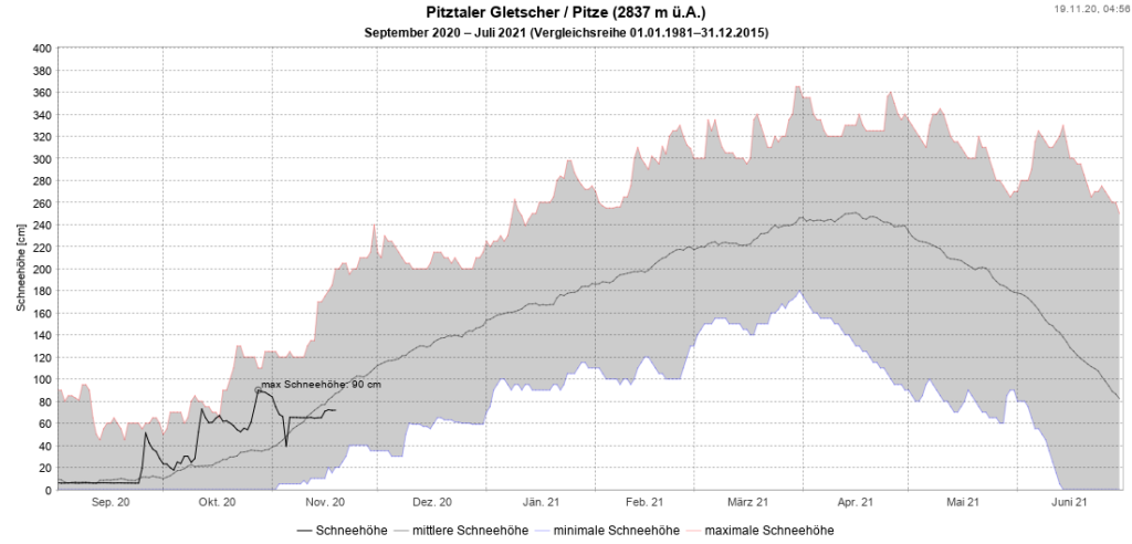
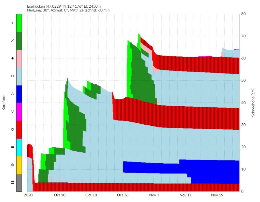
In the last week of September, there was a significant snowfall right up to the higher valley levels. For many locals, it was the start of the new season with stone skiing on a good-natured surface. This was followed at the beginning of October by a sudden onset of foehn winds and light rain up to high alpine altitudes. In mid-October, there was a second significant fresh snow event followed by a moderate warming. This was followed at the end of October by a third heavy snowfall down to the valleys with half a meter of fresh snow in some places. On November 3, it rained lightly again up to almost high alpine regions and the following day the air remained very warm, foggy and damp. Since then, more or less warm high-pressure weather has prevailed with mostly clear skies and fairly dry air, rarely interrupted by any significant fresh snow.

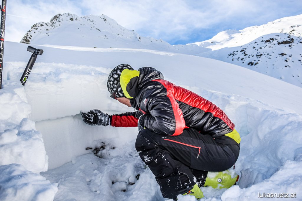
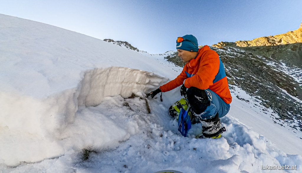
The warm spells have caused a melting crust to form at the top of the fresh snow. Below this, the snow will remain powdery for the time being or, if already settled, compact. However, the high-pressure weather for just over two weeks is changing the snow cover massively - especially on the shady side where the snow has remained, but also on the sunny side on the high mountains, which are snow-covered in all exposures. On very steep south-facing slopes, melting takes place during the day due to the high temperatures and solar radiation - the snow melts on the surface. At night, the snow surface freezes again, cools down considerably and forms a strong temperature gradient to deeper snow layers. As a result, the build-up transformation takes over at night - even in sunny terrain. However, the melting transformation is so strong again during the day that hardly any or only slightly pronounced, constructively transformed weak layers can form.

SnowFlurry
presented by

The situation is completely different on the shaded side and on slopes that only receive brief or weak sunlight. There are also several melt crusts in the snow cover due to rain and warm, moist air. However, no more melting transformation takes place here in fine weather. Even at temperatures up to a few degrees above 0°C. The snow surface always cools down considerably when the sky is clear and remains well below 0°C in the shade. As a result, the snow remains as it is in the short term. However, the temperature gradient between the cold surface and the much warmer layers of snow underneath means that the accumulating transformation continues uninterrupted. Like in an anthill, the water vapor scurries incessantly 24 hours a day from one crystal to the next, where it freezes again. The entire snow cover gradually builds up, the crystals become larger and looser. A weak layer of old snow forms. This process is most pronounced directly below the melting crusts.

For the time being, however, the snow cover does not change for the worse. Except that a load-bearing snow surface is slowly developing more and more into broken snow. This is because not only the snow layers between the crusts are changing, but the crusts themselves are also slowly being "eaten away" from below. The melting forms of the crust slowly transform into loose, glassy and angular crystals. This is because existing weak layers only become a problem when a suitable snow slab lies above them. At present, this is usually still lacking.

For the time being, the only effect on winter sports is deeper sinking or breaking through the snow cover.

Outlook

Weak layers of old snow are therefore already present due to the high-pressure weather since the beginning of November. It is impossible to predict whether and how this will affect the avalanche situation. That depends on the further course, especially on the frequency and intensity of new snowfall.

Theoretically, no relevant old snow problem could develop from this - but that is very unlikely. If it continues to stay clear for weeks with hardly any fresh snow, the scurrying ants will form huge cup crystals in the thin snow cover - which will trickle towards us just by looking at them. We could then have an old snow problem close to the ground throughout the winter as soon as the loose snow cover is overlaid by a suitable snow slab.

Both scenarios, heavy snowfall in the near future or continued good weather, have advantages:

If it snows regularly and in equal amounts, there will probably only be a problem for a few days to a few weeks at most.

If the skies remain clear and the weak layers of old snow only become an old snow problem sometime in December or January after new snow, you can admire the floating snow crystals, shivering snowpack test results and the multi-layered snowpack sandwich, which have been so rare in the last three winters, intensively for another season. Just like in 2014/15, 2015/16 and 2016/17, for example.

Photo gallery

This article has been automatically translated by DeepL with subsequent editing. If you notice any spelling or grammatical errors or if the translation has lost its meaning, please write an e-mail to the editors.

Show original (German)

Related articles

Comments

SnowFlurry
presented by