Skip to content

Cookies 🍪

This site uses cookies that need consent.

Learn more

Zur Powderguide-Startseite Zur Powderguide-Startseite

Language selection

Search PowderGuide

PowderAlerts

PowderAlert 13 2018/19 | Late winter powder the first.

Close call in the northwest!

by Lars Oelmann 03/10/2019
As announced, it will snow several times this week. Now the first dump in the northwest is imminent. And to all those who are wondering why there is only now an alarm: Well, 20cm of snow above 2500m doesn't meet the criteria. Ullr is sending snow from the northwest to the west with strong storm lows and there are always short sunny spells in between. Temperatures go up and down like in westerly weather, but remain more powdery than this weekend.

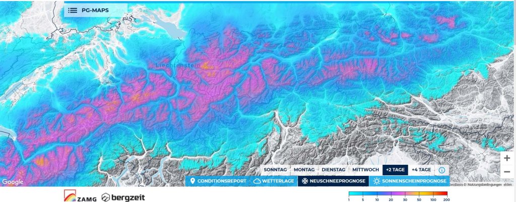
Alert areas and period

From northern France to the Alrberg, until Tuesday morning. It wasn't entirely clear for a long time whether the usable snowfall from now until tomorrow would be enough for an alert, but it actually is.

Wind

The low pressure track from the west means: storm, storm and more storm. The full amounts will be pushed deep into the Valais and along the main ridge and even less may fall in the north-western foothills of the Alps than in the inner Alps. Of course, it will also be dangerous, especially higher up.

Snowfall limit

Was very high, but will quickly drop completely with the current start of this alarm, which means: there is powder where the wind is not raging.

The amounts

From northern France to the Arlberg there are 20-50cm depending on the westerly accumulation and shower yield, whereby 50cm is already the highest of feelings, as the high is moving in quite quickly. There are no real hot spots, but due to the wind, I would assume that the areas in the west jam on the main ridge are more likely to get the most and less the classic, upstream northwest jam. So, for example, the Goms, northern Grisons and the Silvretta rather than Bregenzerwald and, for example, northern central Switzerland.

Where should I go?

I would look for something sheltered from the wind on the main ridge on Monday, which will be well exposed to westerly winds, and on Tuesday I would carefully head for the area of your choice above the tree line, because that's when it will break. The next storm is likely to arrive on Wednesday (and possibly the next alarm on Tuesday).

Mid-term

Another and perhaps somewhat fatter alarm is on the cards for Thursday. The weekend looks a little warmer and further wet, although it is not clear whether it will break up on Saturday or Friday. However, there will still be snow. All weekend warriors should make a few sacrifices for the possible warm peak towards Friday and the weekend, as the models also include cooler variants. So there's still time, and thanks to chaos theory, it would appear to the uninitiated that the change in the main course is a natural process and not the intervention of our favourite Nordic god!

Powder to the people!

Your oracle

Here's the prediction game for this alert.

Photo gallery

This article has been automatically translated by DeepL with subsequent editing. If you notice any spelling or grammatical errors or if the translation has lost its meaning, please write an e-mail to the editors.

Show original (German)

Related articles

Comments