Skip to content

Cookies 🍪

This site uses cookies that need consent.

Learn more

Zur Powderguide-Startseite Zur Powderguide-Startseite

Language selection

Search PowderGuide

PowderAlerts

PowderAlert No. 5 - The next attempt

Now Ullr is making an effort

by Lars Oelmann 01/08/2016
After the last alarm was rather disappointing and it was also quite warm, Ullr finally wants to do us some good and is sending snow again; lots of snow...

Bon Soir dear powder addicts,

Looking back, I'm sorry to say that the last alert fell short of expectations (see small forum analysis), but Ullr finally wants to bring us the First Alert with base AND lots of fresh powder.

I'm writing from the alert area so there are not so many pictures and no umlauts. I'm very sorry as I know how much you appreciate umlauts, but there just aren't any here (editorial gnomes note: this can be added).

This alert goes until Monday night and then a new one should be up because it won't stop snowing!

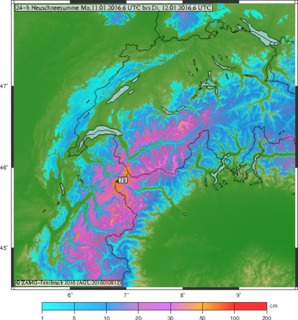
The areas are different to the last alert. There is a lot of snow from France to Valais and less from the Bernese Oberland to the Arlberg, but this time it is also snowing in the southern Alps in Italy and southern Switzerland. But since it's not entirely clear how much is coming there and it has no base, I would advise against a trip.

The totals until midweek Thursday could be more than 1.5 m in the west and thus provide for about 1 m of snow cover growth. BUT THIS IS NOT A PROGNOSIS, because from Monday everything is highly uncertain, so the alarm here only goes until Monday.

Tomorrow morning on Sunday it will start snowing again and even if it gets warm during the day, everything above 1400-1600 m should come as snow. In France, it may rain again up to 1800m. In the south, it will snow much lower down to around 900-1200m.

The amounts

In France and in Wallis there will be around 50 to 80 cm of fresh snow by Monday evening and as it gets colder and accumulates, I may also see the magic 1 meter above 2000 m in one or the other jam hole. In the trees, however, there probably won't be more than 50 or 60 cm anywhere on Monday and that won't happen until late.

From the Berner Oberland to the Arlberg, there should be 25 to 40 cm, possibly even 50 cm here and there. Further east, there will probably be a maximum of 30 cm, or less.

In the south, and I don't really believe this, 40 to 60 cm are supposed to come and in the well-known south hotspots such as Adamello or Slovenia possibly up to 80 cm, but this is so uncertain that I wouldn't be surprised by even half of that. So be prepared for disappointment and rather expect 20 to 50 cm.

When should I go and where?

Early on Monday at the earliest, because tomorrow it will fluff up but from Monday it will be exciting. It will probably still be quite damp below 2000 m in the west on Sunday. Monday will be a nice day in the trees and Tuesday will probably be even lower. So buy some Gauloises and red wine and get in the car.

Outlook after Monday: snow, period.

Poudre a les peuples!

Votre Oracle!

This article has been automatically translated by DeepL with subsequent editing. If you notice any spelling or grammatical errors or if the translation has lost its meaning, please write an e-mail to the editors.

Show original (German)

Related articles

Comments