Skip to content

Cookies 🍪

This site uses cookies that need consent.

Learn more

Zur Powderguide-Startseite Zur Powderguide-Startseite

Language selection

Search PowderGuide

PowderAlerts

PowderAlert No. 8 2015 | Snow for everyone!

Snow for everyone and a real dump in the south

by Lars Oelmann 01/14/2015
After the winter in the north hasn't really worked out recently and most of the old year has melted away, Ullr is returning to its old virtues and remembering the base that it had already distributed in the south above 2000 m in November. So a small südstau is on the cards. But the north, from France to the Arlberg, should also be affected by the passage of the small low, albeit with small amounts of fresh snow.

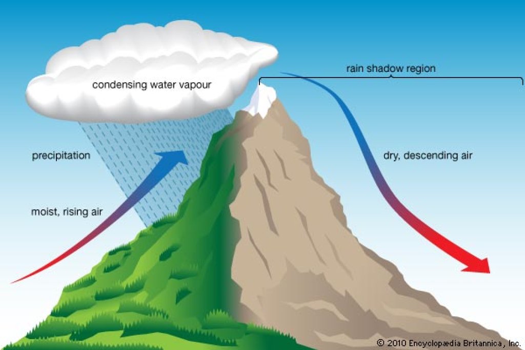
The snow line in the south will initially be a little higher, at 1500 to 1600 m, but will then drop to 1200 m with the onset of precipitation in the south, or even lower if there is heavy precipitation on Friday evening. In the south-east, i.e. towards Veneto and Slovenia, this will last until Saturday. In the north, most of the precipitation will only fall with the arrival of the cold front on Friday evening anyway, so most of it should come as snow above 800 to 1000 m there. Before that, it will be foehn and warm there.

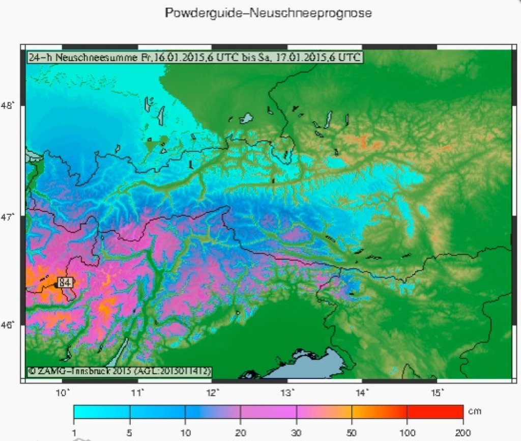
The amounts: As befits a südstau, most of it should come in the south. But the question is where, because strangely enough it's only a small hotspot in the models and the rest will get significantly less.

In the south from Monte Rosa to Slovenia, 50 to 90 cm of snow should fall, although it could be a little less in South Tyrol and the surrounding area if you believe the models, as there is a gap between the core zones.

In the western core zone from Ticino, Upper Engadine to Adamello it will be significantly more than that and the magic meter will certainly be cracked here! Here, 100 to 120 cm of snow will fall across the board and in one or two reservoirs it could even be 150 cm.

In the direction of the main Alpine ridge, the amounts can be significantly reduced as the current will not be as strong, although the incoming front will also lead to snowfall in the north, especially in Switzerland.

In the Lake Alps, strangely enough, despite a southerly current, there will probably be significantly less: between 20 to 40 cm of fresh snow should fall there. From the Hautes Alpes to the Arlberg, 30 to 50 cm may fall with the passage of the front from the west, whereby significantly more may fall on the main Swiss Alpine ridge, especially in the Gottthard region, Goms and central Graubünden, i.e. the borders to the southern core zones, and I wouldn't be surprised to see 50 to 80 cm of Ullr's wonder powder here either.

Somewhat disadvantaged and forgotten by Ullr is the northern Alpine ridge from Tyrol to the deep east of the Rax. Although 20 to 30 cm may fall here, I wouldn't bet on it, especially east of Salzburg.

On the wind side, Ullr is merciful this time and there is no hurricane to accompany the snowfall, so the fresh snow on the much more relaxed base in the south could also invite you to drive with normal caution if you pay attention to the bulletins. Everywhere else, the familiar death traps of recent weeks are still lurking deeper in the snowpack.

What does the oracle advise? Difficult, because there's not enough base anywhere on Friday to enjoy the snowfall. On Saturday it depends on how much falls by midday, whether you can go into the trees then, because in the south there is virtually nothing below 2000 m altitude. So only go into the forest in the morning if you know your way around, otherwise check if there is still some powder on the slopes higher up. On Sunday, it can open up here and there and you can look above the tree line in the south. All in all, it's finally a proper, full-blown dump.

And the best thing is: Ullr understands and it stays cold. Whether he will also send more dumps, more on that - in due course - from the crystal ball.

Powder to the people!

Your Oracle

This article has been automatically translated by DeepL with subsequent editing. If you notice any spelling or grammatical errors or if the translation has lost its meaning, please write an e-mail to the editors.

Show original (German)

Related articles

Comments