Ullr has had an understanding with the snow line in the south this year, however, and has left his successful midfielder from last year, "el Gloppo - the snow heavy from the Mediterranean", on the bench, because the snow line will be almost at the bottom, just like last weekend. The storm from the Ullr's team has also had its teeth pulled out by a mass air transfer and so there will only be wind in moderate doses, so a positive approach can be taken to the dump.
PowderAlerts
PowderAlert No. 15 2015 | Südstau-Bundesliga
Ullr's Südstaubundesliga 2015
Jonas Blum
Val Tours
Marco Tribelhorn
I'd like to welcome everyone to the 5th matchday of the Südstaubundesliga and hope you're looking forward to exciting matches with the Saturday powder as much as I am. Because just in time for the weekend, as with the Bundesliga, the Südstau is starting again and alarming amounts are coming from southwestern Piedmont via Monte Rosa and Ticino to Adamello and the French southwest. This time the models don't show anything further east and there are probably no positive surprises in terms of the track (after the poor Dolomites were very disappointed last week), because it's the same areas as always in the south that are getting snow this winter.
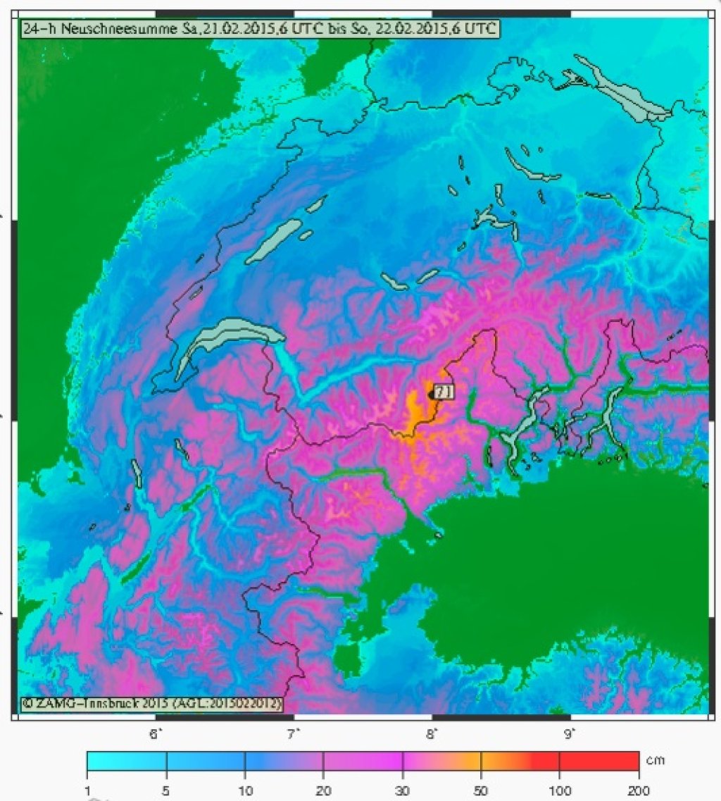
New snow forecast for Saturday, 21.2.2015 for the Western Alps with a clear focus on precipitation in the Southwestern Alps.
ZAMG / PG
New snow forecast for Saturday, 21.2.2015 for the Western Alps with a clear focus on precipitation in the Southwestern Alps.
ZAMG / PG
How high will the final result of the Powder Matchday be?
While in the southwest, i.e. in France from the HautesAlpes down to the Mitteleer, 20 to 40 cm are possible and such amounts are also possible in the very southeast of the Alps towards Carinthia, Julian Alps and Slovenia, Team Ullr will hit the core from MonteRosa to Ticino a little harder again.
Beforehand, however, it should be said that the Maritime Alps could also receive 10 to 20 cm more towards the Mediterranean and the region could get similar amounts to the core, but this is quite uncertain.
For the top game from the Granparadisoostrand via the MonteRosa area to Ticino, you should make sure you have a place, because 35 to 50 cm are possible, and 60 cm or a little more can also be reached in one or two backwater holes.
In the north bad weather is also moving in from the west, but it is unlikely to reach an alarm-worthy 30 cm+ anywhere.
Since it won't start snowing until Saturday, my tip for the weather is to head into the core of last week's snow on Saturday, preferably where nobody has been yet, so that you still have a powder base under the first 10 to 20 cm and then look above the tree line on Sunday when the weather quickly improves from the north.
In the medium term, the forecast has been backed up a bit, but it still looks cool, with a northerly or westerly flow.
So off you go to Ullr's powder stadium in the south.
Powder to the people!
Your oracle
Jonas Blum
Val Tours
Marco Tribelhorn
Jonas Blum
Val Tours
Marco Tribelhorn
This article has been automatically translated by DeepL with subsequent editing. If you notice any spelling or grammatical errors or if the translation has lost its meaning, please write an e-mail to the editors.
Show original (German)Related articles
-
WeatherBlog 14/2015 | Sun and stuff ...
Lea Hartl • 02/18/2015The current weather is a good opportunity to take a closer look at the sun and its radiation. As we know, it is not only responsible for sunburn and the general living conditions on our planet, but also does one or two things to the snow. -
PowderAlert No. 14 2015 | Südstau Alaaf!
Lars Oelmann • 02/12/2015The last alarm for a while, Ullr thinks, and sends us the next pack of Pow in the Alps, just in time for the carnival vacations. Ullr seems to have a soft spot for carnival fans and sends snow to the south and southwest. And in all likelihood, there will be a lot of it by Tuesday. This alert is only valid until Sunday, but I'll try to give you an idea of the total amounts. -
WeatherBlog 13/2015 | January review and outlook
Lea Hartl • 02/11/2015January may have felt relatively wintry, but the statistics have no feelings. February, on the other hand, is currently spring-like in the mountains, while the lowlands are often bobbing along under a blanket of inversion-induced fog.
Comments
Lade...
No comments yet.
-
hTranslated from German.