Skip to content

Cookies 🍪

This site uses cookies that need consent.

Learn more

Zur Powderguide-Startseite Zur Powderguide-Startseite

Language selection

Search PowderGuide

WeatherBlogs

WetterBlog 21 2023/24 | Winter restart - how could this happen?

High pressure determines low pressure

by Sebastian Müller 04/24/2024
A short while ago we were water-skiing or riding bikes, and now, at the end of April, we suddenly find ourselves in winter. How could this have happened? It's cold throughout the Alps and it's snowing quite a lot, especially on the northern slopes. If you really missed it, 2 PowderAlarms and rows of 4-star ConditionsReports should be enough proof. Powder skis should be the first choice up to and including the weekend!

The weather situation

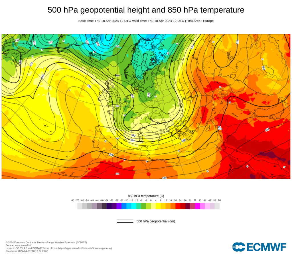
The current synoptic weather situation manifested itself over a week ago. It was Tuesday and I was still sitting in the warm sun in Trieste at lunchtime and there were only a few high clouds to indicate a change in the weather. The cold front then hit us with thunder, lightning and squalls, because the warm, humid air mass had to leave, namely as thundery convection upwards. This meant that the entire Alpine region was finally enveloped in arctic-cold air masses. The temperature plummeted by well over 10 degrees Celsius, and it must be remembered that (maximum) temperature records had been broken shortly before.

WeatherBlogs
presented by

The basis of this weather situation can be found in the Azores High. It stretches far to the north, preventing a warm and humid westerly flow, but also remains well positioned in the Atlantic. In this orientation, it allows cold, moist air masses from the Arctic to flow deep into Central Europe on its eastern flank. The synoptic circulation (the weather situation) can be described in many different ways, but pressure systems are always the central element as they determine the flow. Attributing the onset of winter to the Azores High seems simplistic but fair. On the other hand, one could also emphasise that we are in a deep trough, but that is irrelevant. The southern side of the Alps also experienced a Föhn wind, but it was still cool, as well as a leeward cyclogenesis, which then brought snow here too. More than half a metre of snow fell in large parts of the northern Alps, and the south is just getting it. The snow conditions for the alpine touring season were once again greatly improved, although the snow line was largely below 1000 metres.

Finally, we find the kind of winter weather we always dream of. The appearance of this weather at the end of April may be surprising, but let's not blame it on global warming. But well, if that's the case, then I'll be ready to go ski touring in the summer!

The prospects

But of course, winter will not stay and at some point summer will come. The Azores High will collapse and will no longer be able to stop the westerly and southerly currents. Central Europe will green up and blossom again. I think we can live with that. A final assessment of the season is still pending, because we're going powdering again this weekend, it could be very worthwhile!

This article has been automatically translated by DeepL with subsequent editing. If you notice any spelling or grammatical errors or if the translation has lost its meaning, please write an e-mail to the editors.

Show original (German)

Related articles

Comments

WeatherBlogs
presented by