Skip to content

Cookies 🍪

This site uses cookies that need consent.

Learn more

Zur Powderguide-Startseite Zur Powderguide-Startseite

Language selection

Search PowderGuide

WeatherBlogs

WeatherBlog 10 2020/21 | Föhn and snow replenishment in the south

Rising temperatures, still turbulent

by Lea Hartl 01/20/2021
A southerly foehn will end the cold, snowy winter weather phase in the northern Alps for the time being. The controlling low lies over the British Isles and, as is so often the case, warm air from the southwest will be brought to the Alpine arc. In the north, the next few days will be characterized by Föhn winds, in the south it will be cloudy with - depending on the altitude - liquid or solid accumulated precipitation.

Current situation and outlook

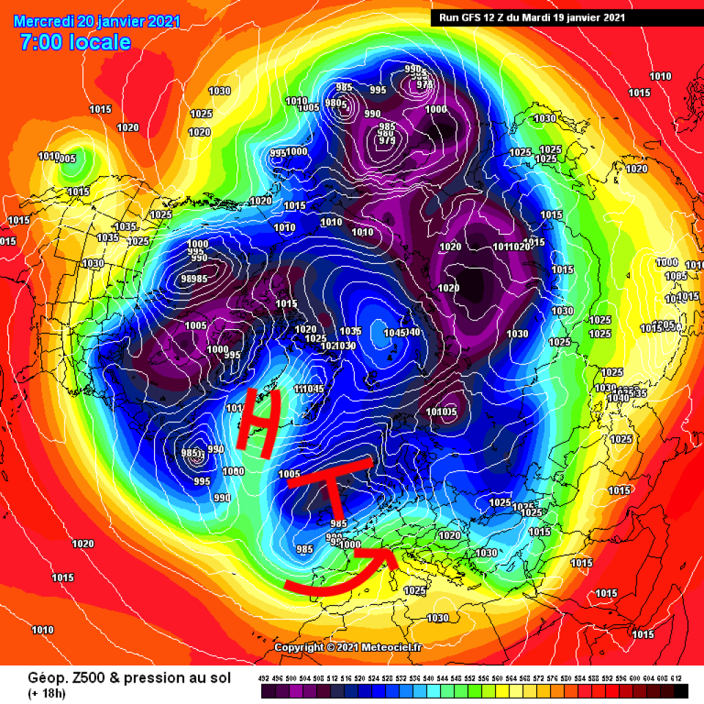
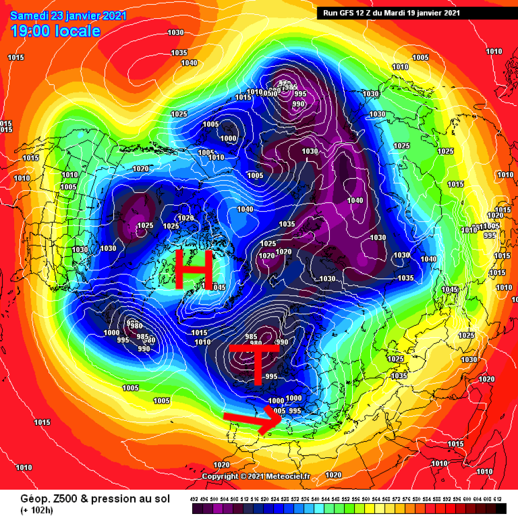
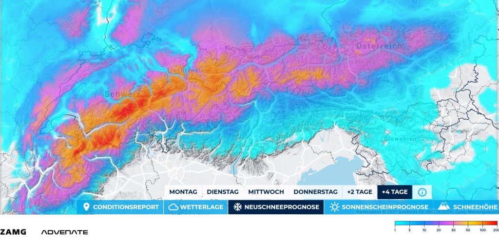
Yesterday, Tuesday, was significantly warmer than the last few days. The north-westerly current turned to the west and will shift completely to the south-west today at the latest. This means that the Föhn will become increasingly noticeable in the north, while clouds will increasingly accumulate against the main ridge in the south as the day progresses. Precipitation will fall in places in the south in the evening. The snow line in the south will be higher than recently, with rain more likely at lower altitudes. In the north, the zero degree line will probably climb to higher altitudes, but it will remain mostly dry here. Thursday will be basically similar, but everything will be slightly more intense than on Wednesday: südstau with moderate precipitation in typical accumulation regions, stormy Föhn in the north. In terms of fresh snow, it will be exciting again in the südstau with a cold front on Friday or in the night from Thursday to Friday, which could also bring larger amounts regionally - especially in the southeast. We expect a report from the oracle on the next few days soon.

WeatherBlogs
presented by

In the north, it will remain variably cloudy, rather windy and generally unsettled. In the course of Friday, the current is likely to shift back to the NW and the next cold front will probably arrive in the evening. The exact development at the weekend is still very uncertain. The weather is likely to be unsettled from the west, with "friendlier" conditions most likely on Saturday morning from today's perspective. After that, more fronts are on the horizon, especially in the western Alps, with quite a lot of snow potential. As I said, everything is still quite shaky. However, calm, persistent high-pressure weather is not on the cards for the time being.

Look at the general weather situation

The turbulent weather over the next few days is largely due to the aforementioned low-pressure complex in the area of the British Isles, which has several centers and is slowly shifting back and forth, but is not changing its position much in the meantime. At present, the Atlantic is virtually "sealed off" by a kind of Greenland block. The westerly drift cannot get past a high wedge that extends all the way to Greenland. It therefore cannot push our low away either. The high pressure over Greenland will remain in place for the time being, but it seems that it will gradually be pushed away towards the weekend, allowing Atlantic lows to move more directly towards Europe again: A possible recipe for westerly weather in the Alps despite the not very round polar vortex.

Switzerland is getting warmer

We'll briefly jump from the weather to the climate: in a blog post worth reading, MeteoSwiss once again impressively presents how Switzerland's climate has changed in recent decades. The 2011-2020 decade was by far the warmest since measurements began. Compared to the reference period 1871-1900 (pre-industrial), the past decade was 2.5°C warmer in Switzerland. Since the 1970s, the upward trend in the decade averages has been permanently positive, i.e. since then a decade has always been warmer than the previous one. It doesn't have to be new cold records, but at least moderating this trend somewhat would be very desirable for 2021-2030!

This article has been automatically translated by DeepL with subsequent editing. If you notice any spelling or grammatical errors or if the translation has lost its meaning, please write an e-mail to the editors.

Show original (German)

Related articles

Comments

WeatherBlogs
presented by