Skip to content

Cookies 🍪

This site uses cookies that need consent.

Learn more

Zur Powderguide-Startseite Zur Powderguide-Startseite

Language selection

Search PowderGuide

SnowFlurry

SnowFlurry 1 2023/24 | Christmas thaw

... and the influence of rain on the snow cover

by Lydia Knappe 02/04/2024
Fortunately, this season got off to a very snowy start and provided a good foundation. It stayed that way until shortly before Christmas. The so-called Christmas thaw materialised just in time for Christmas.

The Christmas thaw

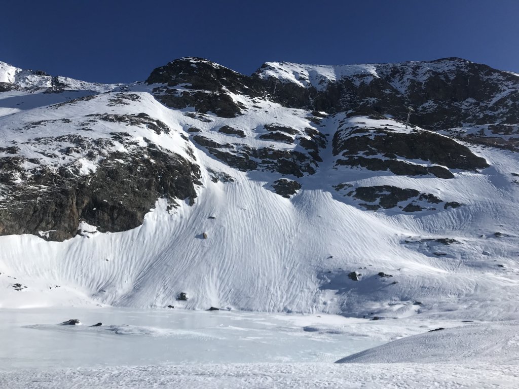
This mild, wet weather period occurs in Central Europe between 15 December and 15 January in just under seven out of ten years and is referred to as a climatological singularity or recurring weather event. In meteorology, a singularity is generally understood to be a rare but recurring short-term weather event in a particular region. One trigger for the Christmas thaw can be the onset of the polar night in Scandinavia at the end of November. Due to the lack of sunlight, a cold high forms. If this is displaced by an easterly current, this can open the way for warm, humid air from the west and south-west. This brings rainfall and mild temperatures. The precipitation can reach up to summits. Due to the frozen ground, there is no possibility of seepage, which is why the precipitation turns into surface runoff and leaves behind typical structures in the snow, such as melt channels (see image). Although the occurrence of this singularity is statistically significant, its calendar link is not so strong that it can be used for weather forecasting. In addition, it is difficult to clearly explain such singularities in a region such as Europe, as temperatures and precipitation are subject to strong interannual (periodic) variability. In the Alps in particular, the complex orography can also lead to local effects.

SnowFlurry
presented by

But how does this affect the avalanche situation? - The ambivalent influence of rain on the snowpack

(We have also addressed this topic in previous snow flurries)

The negative influence:

"Rain almost always leads to an increase in avalanche risk in the short term" (Mair & Nairz 2010). On the one hand, this is due to the additional load of the percolating water within the snowpack, on the other hand, the rain can disrupt the connections prevailing under the snow crystals and thus act as a kind of lubricant, especially due to the inhibited infiltration properties of the frozen ground, which leads to runoff between the ground and the snowpack and thus to instability. This can manifest itself in spontaneous avalanche activity.

The positive effect:

As the positive temperatures drive melt metamorphosis, rain can have a stabilising effect in the medium and long term. However, the prerequisite for this is that the temperatures drop after the precipitation event. Sufficient cooling causes the water in the pores to freeze and the snow cover to solidify. Melt crusts, snow caps and melt channels are recognisable forms in the terrain.

Effects:

If such a warm phase is followed by a cold phase, with the potential condition that the moist, wet snow does not freeze through completely, there is a treacherous avalanche problem: cold to warm. This creates a large temperature gradient within the snowpack, which favours build-up transformation processes in the snowpack and thus possible weak layers. As already mentioned, rain can cause a melting snow cover to form. Due to condensation and resublimation processes within the snowpack, which result from the vapour pressure gradient between the deeper, wetter, warmer snow and the drier, colder snow near the surface, a build-up transformation layer forms underneath the melted snow cover. With fresh (drifting) snow, the new snow pack including the harsch cover can now detach from the weak layer. It should be noted that this weak layer only forms after the snow has fallen.

The impact of both negative and positive effects on the avalanche situation could also be observed this winter with the occurrence of the Christmas thaw. Spontaneous sliding snow avalanches subsided, the snowpack subsequently stabilised due to falling temperatures, and the Tyrol Avalanche Bulletin warned of the possibility of a weak layer forming

Résumé:

The warm and humid weather, which often causes the prospects of snow to melt around Christmas, can be explained by certain constellations of large-scale weather conditions. The precipitation, which can fall as rain up to high altitudes, initially has a negative effect on the avalanche situation, but also stabilises the snow cover by promoting melt metamorphosis. However, the pleasure of skiing is diminished by the formation of snow caps, melt crusts and channels. Precipitation in the form of snow due to lower temperatures should be observed with caution. This can result in a weak layer within the snow cover about two days after the precipitation event.

Literature:
Mair, R. & Nairz, P. (2010): Avalanche. Practical handbook by Rudi Mair and Patrick Nairz. Recognising the 10 decisive danger patterns. Tyrolia publishing house, Innsbruck.

This article has been automatically translated by DeepL with subsequent editing. If you notice any spelling or grammatical errors or if the translation has lost its meaning, please write an e-mail to the editors.

Show original (German)

Comments

SnowFlurry
presented by