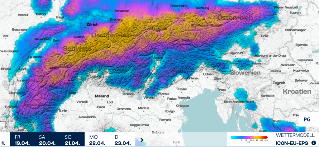
Skip to content

Cookies 🍪

This site uses cookies that need consent.

Learn more

Zur Powderguide-Startseite Zur Powderguide-Startseite

Language selection

Search PowderGuide

PowderAlerts

PowderAlert 15 2023/ 24 | All good things must come to an end!

One last alert before the summer break!

by Lars Oelmann 04/19/2024
With this last nordstau, Ullr is sending us what could be the last cold snowfall suitable for weekends and the oracle is using this opportunity to bid a highly official farewell to the summer break, as medium range forecast does not look like there will be any more wintry surprises until the end of April.

All in all, we can be satisfied this year, because there were a few opportunities to ski powder and plenty of snow further up. There was also a lot of rain further down, but that's the way it is in times of climate change.

Alert period and areas

The alert goes from Friday afternoon to Sunday evening and extends from the northern Valais to the Rax. The core extends from the Bernese Oberland to the Arlberg.

Wind

Today on Friday quite stormy from the west, from tonight moderate from the north and then also quite strong Stau. Nevertheless, large amounts again in the foothills of the Alps and in the Stau region.

Ad

Snowfall line

Climbs briefly to 1000-1200m today, then drops back to 600-900m tonight. Full amounts from 1400-1600m

The quantities

There will be 30-50cm across the entire northern Alps. In the core it will probably be 50-70cm and with perfect nordstau I see potential for surprises upwards, in central Switzerland and other powder holes up to 80 or 90cm. We won't manage that metre, the oracle believes.

Where should I go?

It's going to be socked in all day on Saturday, so head for the alpine meadows that have already had some snow, or if there's enough in the trees somewhere in central Switzerland or on the Arlberg, then head there. As there's already a lot coming tonight, you should be out and about early on Saturday to maximise the fluffiness and beat the daytime warming in spring. (Even with snowfall, the diffuse radiation in April has power).

Sunday will be showery. Season pass holders can speculate on a short break in the clouds at midday, but everyone else should rather stay in the trees.

It should clear up on Monday and at least be suitable for the ski area in the morning, with possible showers in the afternoon and the rest of the days until Wednesday. It will stay cold until Wednesday and those who can take a holiday can still find good powder on the north side in fairly stable conditions. That's the good thing about spring.

Medium range

It's slowly warming up towards average, but there's no sign of massive pow or new summer days until next weekend. So it's skiable. But since the pressure distribution will remain flat and the polar air will continue to age, I would expect clouds and showers in the afternoon.

Powder to the people and see you next year!

Your oracle

This article has been automatically translated by DeepL with subsequent editing. If you notice any spelling or grammatical errors or if the translation has lost its meaning, please write an e-mail to the editors.

Show original (German)

Comments