Skip to content

Cookies 🍪

This site uses cookies that need consent.

Learn more

Zur Powderguide-Startseite Zur Powderguide-Startseite

Language selection

Search PowderGuide

PowderAlerts

PowderAlert 6 2018/19 | North jam the third, or off to the bunker?

The question is not: Where is it deepest? But rather: What is still open?

by Lars Oelmann 01/04/2019
Ullr means well with us. Unfortunately too well. As with all triologies, the grand finale comes at the end: the return of King Ullr. But he wants to make the Eastern Alps look more like the second Star Wars and turns everything into the ice planet Hoth.

As announced, it's going to be huge. The oracle is currently sitting in the northern congestion of the Eastern Alps and is fleeing towards the highway today and tomorrow to the one ski resort that is open. Or it's going home. That means the alert is going to get really wild, because I'm not normally squeamish.

So read the bulletins and check for road closures. I'm not an LLB employee, but Sunday or Monday all the ingredients for a 5 are there.

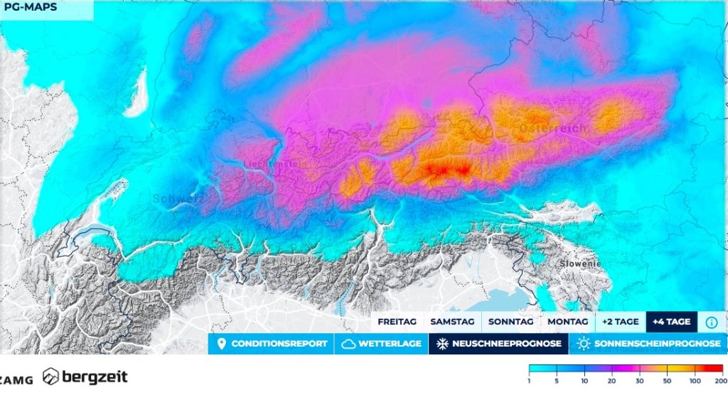
Time period and areas

The alert applies from central Switzerland to the far east. The core lies between the Arlberg and the east, although it only gets really apocalyptic from the Nordkette onwards.

The alert is valid until Monday evening. Then it should stop. Therefore, one day longer than normal.

Snowfall limit

Going up and down and can go up to 1000m in the west and stay around 600m in the east within the Alps. Sunday/Monday will be a bit colder again, but generally very suitable for powder. The full amounts are available from 1200m.

The amounts

Ullr is dumping snow with a coarse trowel. From central Switzerland to the Arlberg there will be 40-70cm of fresh snow and on the Arlberg and up to the Nordkette 70-100cm.

From the Nordkette to the east there will be 100-150cm of fresh snow, in the congested areas from Salzburg to Styria even 2m or more.

Where should I go?

To a place that is not at risk of avalanches and is close to the highway, to look for the last open ski areas from there.

You can only ski deep below the tree line anyway. And even then only very, very carefully.

Tuesday there should be no more snow, but it's unclear whether it will break up. However, you shouldn't want to ski at the top anyway.

Medium term

No sleep until record January!

It remains quite cold and the next northerly storm (alert 7) is probably waiting in the wings for Wednesday. This time it's more likely to hit the west. All in all, it will remain powder-suitable and exciting.

Powder to the people!

And take care!

Your oracle.

This article has been automatically translated by DeepL with subsequent editing. If you notice any spelling or grammatical errors or if the translation has lost its meaning, please write an e-mail to the editors.

Show original (German)

Related articles

Comments