Skip to content

Cookies 🍪

This site uses cookies that need consent.

Learn more

Zur Powderguide-Startseite Zur Powderguide-Startseite

Language selection

Search PowderGuide

PowderAlerts

PowderAlert 15 2019/20 | More Powder.

The west has a base and now it's snowing there again, but also in the southeast.

by Lars Oelmann 03/01/2020
On the way back to a normal season? After the rather tough course of this winter, some regions, at least in the west, are now on the way to an average season. There is a base and it continues to snow. Ullr is also making a rendezvous in the south-east and there's still plenty of snow above 1800m.

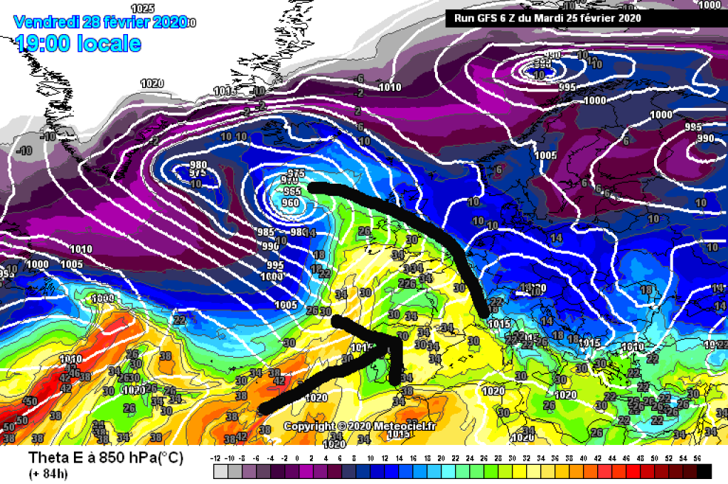
The oracle is still enjoying the memories of alert 14, but Ullr is not letting up and is sending us further disturbances from the west and southwest into the Alps, so that the regions continue to be supplied with snow. The current also has a southerly component and so it's snowing in the south again for the first time in a while. After that, it's going to be a lively week and there should be another alarm on Tuesday. More on this in the medium term.

Alert period and areas

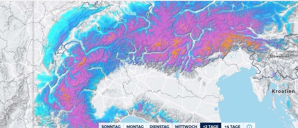
It is snowing from France across the Maritime Alps and from Ticino to the east in alarm-worthy amounts. However, the core lies from Trentino via the Dolomites to the border triangle near Slovenia. Most of all, as usual in such a situation, in the Julian Alps.

The northern Alps and especially the north-east will be left out in the cold. It's more likely to be foehn-like.

The alert will last until Tuesday morning, with only a short break on Tuesday before it theoretically snows again.

Wind

Hold on tight, it won't be very windy. Even at 3000m, the models are only seeing some blustery winds here and there where it's snowing. So for what seems like forever, Ullr has been sending us lots of snow and quite little wind.

Snowfall limit

Little wind? And even partly already base? There must be a catch here, right? The oracle said it would be southwest, so it's bound to be abnormally warm?

No. Here too, Ullr gives us the green light and leaves it between below 1000 and around 1500m with snow. Below 1000 is more likely in the inner Alps in the west with heavy precipitation, 1500m in the Maritime Alps, generally in the foothills of the Alps and in the southeast.

The amounts

From 1000-1500m, 30-60cm of snow will fall from France via the Maritime Alps to the Upper Engadine. In northern France it's more like 30, more towards the south.

From the Upper Engadine to the east 50-80cm and in the border triangle also 70-100cm. In the Julian Alps it can also reach 120cm.

Where should I go?

While it is snowing, I would recommend the trees in the west, especially in the Isere or Savoy region, as there is still a base there from the last snowfalls. I'm not sure about the south and south-east. Depending on your taste, you can check the local meadows and pastures there, but I would advise against trees unless I have overlooked secret spots with a base.

On Tuesday you can check the snow everywhere in the sun, which should still be powdery even at higher altitudes.

Then it will probably start snowing again and it will be a new alarm rather than relaxed touring.

Mid-term

Tuesday will see a new alarm. Where and how much and how long it will snow then is still unclear, but if you want to stay somewhere this week, the models and Ullr's crystal ball recommend France (especially Isere down to the Hautes Alpes), where you have the first alarm and then possibly more real snow on Thursday and Friday, and possibly again without much wind. There may also be some in the northern Alps west of the Arlberg, but that's shaky and the amounts are lower, so the week in France is a better bet.

#endlichinstagramconditions #miraclemarch #desorakelshastagssisn'tawaytobecomea successofpowderguidebecauseyoudon'ttakeittooseriouslyinweb4.0

Powder to the people!

Your euphoric oracle

Photo gallery

This article has been automatically translated by DeepL with subsequent editing. If you notice any spelling or grammatical errors or if the translation has lost its meaning, please write an e-mail to the editors.

Show original (German)

Related articles

Comments