Skip to content

Cookies 🍪

This site uses cookies that need consent.

Learn more

Zur Powderguide-Startseite Zur Powderguide-Startseite

Language selection

Search PowderGuide

PowderAlerts

PowderAlert 11 2019/20 | Finally snow again!

Unfortunately, it's not a sustainable alarm, but at least it's a real package!

by Lars Oelmann 01/27/2020
Everything back to the start. After a good start, hardly any snow has fallen since Christmas and it feels like we're back in November, but finally Ullr has seen sense and sends us a winter greeting again. Unfortunately, he has to get back into the groove and it won't last, but more on that in the alert.

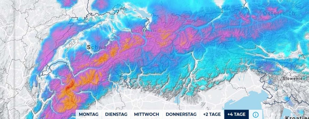
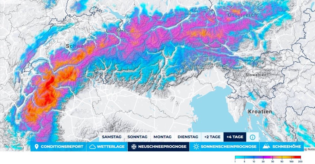
There has been no alarm since December 21, i.e. for over 5 weeks. The oracle has thought of everything but skiing. But now it's starting again.

Alert period and areas

The alert goes from the Hautes Alpes to the Arlberg. There's also something to the east, but it's just scraping by on the alert amounts.

The core is between western Valais and Savoy.

The alert lasts until Wednesday evening, when all of Ullr's gifts should be on the ground.

Wind

It's stormy. First from the south and then from the northwest. Combined with the considerable amounts of snow and the often building foundations, it will be quite unpleasant.

But it will also push the full amounts into Valais and along the French-Italian main ridge.

Snowfall line

This looks pretty good! It starts at 1000-1200m and then goes down further. Winter! For a change, not just according to the calendar.

The amounts

From the Arlberg to the west in the Hautes Alpes there will be 40-70cm of fresh snow, in the core from western Valais to Savoy there will be a good 60-90cm and there may also be a pothole in France somewhere that cracks the meter.

East of the Arlberg it's hovering at or just below alarm levels.

Where should I go?

Tomorrow, Tuesday, I have no idea, because there's not enough snow anywhere in the forest in the north, is there? Possibly higher forest aisles, or you know your way around the western Valais and France well.

Wednesday could be a bit more in the trees, but only in places with a bit of a base, because it's unlikely to be groundless.

Thursday it'll crack open at the top before it gets warmer and snows again in the afternoon. You could go up there, but you should be really careful and first see what the fresh snow does to the foundation from the drought. Don't get greedy, even if it hasn't snowed for ages!

Medium-term

Rather meh. Because as soon as it's been winter for two days, we're back in the tropics. By the weekend, it will be really warm and remain windy, so more of a student alert this week. In addition, there's always precipitation, so you can't even go out high. Friday-Saturday it will rain again towards 2000m, so the alarm will be a short-lived pleasure.

At the far end of the crystal ball, something is happening in the northern hemisphere, but it's still so uncertain that I'm expecting a train rather than the end of the tunnel. But you can keep an eye on the models in the middle to end of next week. Hope is higher than the last few weeks.

Powder to the people!

Your oracle

This article has been automatically translated by DeepL with subsequent editing. If you notice any spelling or grammatical errors or if the translation has lost its meaning, please write an e-mail to the editors.

Show original (German)

Related articles

Comments