Skip to content

Cookies 🍪

This site uses cookies that need consent.

Learn more

Zur Powderguide-Startseite Zur Powderguide-Startseite

Language selection

Search PowderGuide

PowderAlerts

PowderAlert 11 2017/18 | In the south it's "This Alarm goes to Eleven"

ARE YOU READY?

by Lars Oelmann 12/25/2017
It's getting warmer and everyone fears the worst, but Ullr comes back on stage with verve and roars: ARE YOU READY? If you don't know the allusion from the metal mockumentary "This is Spinal Tap", you're in luck:

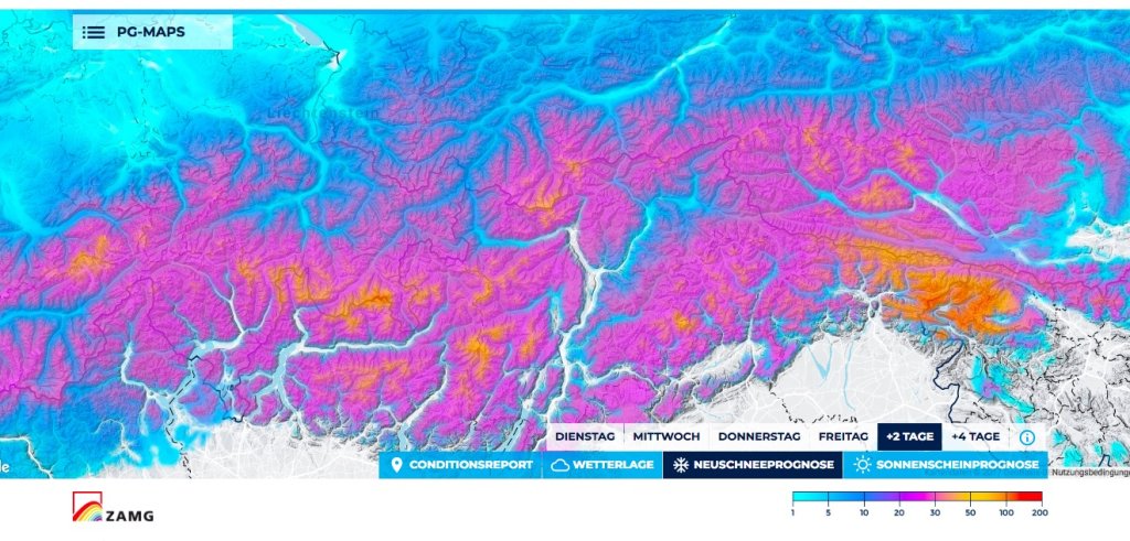
Ullr is at it again, bringing snow to our Alps, and although it's going to be a south(west) jam, I have good news about the snow line. In the southeast it's going to be real, deep and cold. It will be very pretty in the rest of the south and quite nice in the west. There may be something in the north afterwards, but more on that in the medium term.

Alert area and period

Area: French Alps, especially Maritime Alps, and in the south from Ticino (possibly Simplon) to Slovenia.

Time period: Until Thursday morning. In the north there will probably be an alarm tomorrow evening, which will follow seamlessly.

Snow line

At the beginning around or in Ticino and inner Alps below 1000m, possibly also 1200m in the southeast and then sinks (sic!) further down until Thursday. In France it may rain up to 1500m, especially in the north-west, thanks to foehn effects, but then it will probably transition seamlessly into the north-west alert afterwards. So real powder in the south this time!

Ad

Wind

The wind from Ullr's dump amplifiers is blowing gale-force winds around our ears. In combination with the weak snowpack foundation in the south, it gets very unpleasant when it breaks up. Don't be naive powder groupies and watch out if it gets sunny in the south on Thursday!

The amounts

In France, 30-40cm are coming. There may be 50cm here and there south of the Ecrins or in the Maritime Alps. In the south, 40-60cm with up to 70 in the one or other backwater. As it turns north really quickly, I don't see much potential for surprises up there.

In the south-east, it's going to be rock star low, because Ullr is sending large amounts in a short time. In the border triangle It/At/Slo, 70-110cm will probably come and in the Julian Alps I wouldn't want to rule out 150cm either. And yes, this time it's not just coming from 2000m!

Where should I go?

I would only go to France if you are there. In the rest of the south, I'd try tomorrow in the trees and then carefully further up on Thursday. I see it similarly in the far southeast, although it might not break up there until Thursday afternoon-evening, which would then shift the whole thing to Friday.

Mid-term

First cold and northwesterly tomorrow evening, then probably rather "meh" and warm over New Year's Eve and New Year's Day. Then maybe west-northwest again with okay snowfall. Or not, because it will change to southwest. It's still quite uncertain what kind of westerly flow is coming, the only certainty is that a westerly flow is coming.

That's why I'm asking for your help at the Ullrschrein to make it just as nice as it is now after the holidays!

So dear Southeasterners: "Enjoy the Show"

I'm sure it will be quite impressive this time.

Powder to the people!

Your Oracle

P.S. Prediction game as always under here.

This article has been automatically translated by DeepL with subsequent editing. If you notice any spelling or grammatical errors or if the translation has lost its meaning, please write an e-mail to the editors.

Show original (German)

Related articles

Comments