Skip to content

Cookies 🍪

This site uses cookies that need consent.

Learn more

Zur Powderguide-Startseite Zur Powderguide-Startseite

Language selection

Search PowderGuide

interviews

Interview | Sebastian about the new PowderGuide Weather

The background and introduction to PG-ICON weather

by Lorenzo Rieg 11/28/2023
With the new PowderGuide website, we are also presenting our community with a completely new weather service: the PG-ICON weather. Sebastian, who is probably best known to most readers from our "Videos of the week" section, is in charge of this. Sebastian holds a doctorate in meteorology and is currently researching tropical precipitation in high-resolution global climate models at the University of Trento. We are very happy to have Sebastian as a specialist in our team and are delighted to be able to introduce him and the new PG-ICON weather with an interview.

Hi Sebastian! Nice that we can meet for an interview where we will learn all about the new weather maps at PowderGuide and how they are created.

But first a little bit about you. Where are you from, what do you do, why are you drawn to the winter mountains and how did you come to PowderGuide?

Ciao Lorenzo, the pleasure is all mine. I grew up in a small town in Lower Bavaria and learnt to ski from a very young age in the Bavarian forest. I now live on the southern side of the Alps and consider the Julian Alps and the Friulian Dolomites to be my local mountains. I've known PG for what feels like forever. At some point I ordered ski straps and asked why the "videos of the week" were no longer available... and then it took its course!

Let's move on to the weather. You studied meteorology and your research focuses on regional and high-resolution climate models. How did this come about and what is it that you are particularly interested in?

I started by studying physics at the LMU in Munich, and after two semesters I wanted more nature in physics and switched to a B.Sc. in physics plus meteorology. That worked out really well straight away and I've been working in research ever since, with convective clouds as the primary topic. Understanding the weather phenomena that constantly surround us is a special attraction, and the complexity of our atmosphere is a never-ending challenge.

With that background, it's an obvious connection, and you've also taken over the weather blog for part of the last few winters. Nevertheless, how did it come about that you took care of the new weather content at PowderGuide, and what was the process like?

That wasn't even planned at first. I was involved in the redesign of our website and at some point the question arose as to how our weather service should be organised. There was even a discussion about whether we should perhaps suspend it for cost reasons. I then suggested exploring the feasibility of an independent PG weather service and contacted the DWD (German Weather Service) and was immediately told that all their forecasts were freely available. Then I was able to create the well-known forecast products without any problems, and then we pretty much agreed that this was feasible and could be worthwhile.

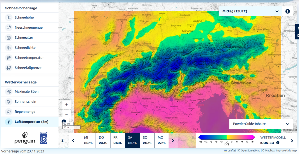
Let's move on to the new page and the weather content on PowderGuide, what products can I find on the new page?

Yes, we find everything that our community already knows: snow depths and their changes, sunshine duration and of course the amount of new snow. Then we also found variables in the output data that describe the condition of the modelled snow cover: snow age, snow density and snow temperature. These can (to the best of my knowledge) only be found here. We round off our range with the snow line, the maximum gusts, the amount of rain and the air temperature near the ground, and finally we also have ensemble models in our repertoire!

That really is something new! Will the information be taken 1:1 from the model, or will something else be changed for the display on PowderGuide?

The grid structure of ICON is based on an icosahedron, which can be divided into any number of triangles. This allows a uniform spatial resolution to be achieved over the entire globe. We interpolate this data onto a correspondingly high-resolution lat-long grid and create our plots. These image files are then used to create tiles for the different zoom levels, which we finally get to see. Apart from this remapping, we do not carry out any manipulations.

The weather information provided on PowderGuide has changed significantly with the new site. Up to and including last season, the data was largely based on the regional weather model of the Austrian weather service, GeoSphere Austria (formerly the Central Institute for Meteorology and Geophysics), which we bought in. Now we use different data. Can you explain what the difference is and what the new data is all about?

All the forecasts shown are calculated operationally by the DWD with its ICON model, both globally and regionally on refined grids for Europe (ICON-EU) and for Germany and the Alpine region (ICON-D2). Now I don't know which model GeoSphere uses, but ICON is certainly one of the best weather and climate models. The ICON-D2 model is particularly promising because of its fine grid with a width of 2.2km. Nevertheless, this does not guarantee a perfect forecast, because the determination of the initial state of the atmosphere cannot be perfect and the error growth in the atmosphere is non-linear.

One approach to deal with prediction uncertainties is to use an ensemble: This means that not only a single (deterministic) model is calculated, but an ensemble consisting of many predictions (20 for ICON-D2, 40 for ICON-EU), each of which is started with slightly different initial conditions. This allows the quality of the prediction to be assessed: If the individual ensemble forecasts diverge greatly from each other, then the given large-scale weather situation is very susceptible to small disturbances and the quality of the (deterministic) forecast is low. Conversely, weather conditions dominated by stable high-pressure systems, for example, are very reliable and the individual ensemble simulations differ only slightly, meaning that the forecast is very reliable. In our PG-ICON weather we offer the ensemble forecast systems (EPS) ICON-D2-EPS and ICON-EU-EPS, which are difficult to find elsewhere. We show the average of all ensemble forecasts, which can be regarded as the most probable forecast, and also the minimum and maximum, which can be regarded as the most pessimistic and optimistic forecasts for the prediction of fresh snow. Finally, we use the ensemble to calculate the probability of the occurrence of a critical amount of fresh snow.

All right, so we have good data for the time being and can even recognise the quality of the forecast using the information from the ensembles. What do you look at on the PowderGuide maps yourself when you want to find out where it's snowing a lot, or the most, or where you want to go skiing in the next few days?

Well, I'll keep a very regular eye on the amount of fresh snow and take a closer look when something comes up. That means checking the snow conditions, temperatures and wind gusts, which should work with the available masks (influences).

Great, there's a lot on offer now that goes far beyond just information on precipitation. What do you think is particularly exciting?

I'm particularly excited about snow density and snow temperature. We will probably only see how helpful and reliable these variables are as the season progresses, but the first impressions are promising. Then, of course, I find the ensemble models exciting, especially the probability of the occurrence of a critical amount of new snow, in this case 15 cm. Finally, I have added masks (influences) to the deterministic new snow forecast, which indicate where new snowfall is influenced by warmth, wind or a lack of base. Perhaps some fine-tuning will be done here over the course of the season. I'm also particularly looking forward to the feedback from our community, and of course we still have a few extensions in mind - let's see!

And what do you recommend for dealing with weather information and forecasts, especially with regard to our tour planning? How much can I rely on the information on PowderGuide or elsewhere?

The ICON forecasts we show are certainly of the best quality, but weather forecasts from any model cannot claim to be correct. Numerical weather prediction remains an eternal challenge due to the complexity and non-linearity of the atmosphere: All models are wrong, but some are useful (George Box)!  Avalanche warning services have a real responsibility in this respect, and checking the avalanche situation report is essential for anyone who goes out into the snow.

If we look at the past, the weather forecast in general and also the offer on PowderGuide has continued to improve in recent years. What is the reason for this and can we expect further developments like this in the future?

I think we are at a very interesting point in operational weather forecasting and ICON-D2 is a prime example of this development: thanks to increased computing capacity, a grid width of 2.2km has now been achieved, which should significantly improve the simulation of all processes related to complex orography and convective clouds: precipitation, local wind systems and temperatures. However, we also recognise that on larger time and space scales, high-resolution models have their difficulties and the coarser models with parameterisations often work better. Therefore, ICON-D2 seems to be an ideal system because of its spatially and temporally limited scales. Finally, the development of numerical weather prediction will also be largely determined by the introduction of artificial intelligence (AI) into forecasting systems. Although AI has huge potential and has already demonstrated this, it can also fail due to the displacement of physical laws..

What would you like to see for these future developments, both for freeriders and beyond?

I hope that the weather forecasts are both valuable and inspiring. The weather forecast is always part of tour planning and I hope we can contribute some valuable information. Regarding the current and future global warming, I think we need to be flexible and patient. There will always be really good snow days that are worth waiting for, and then hopefully you can take the day off and set off. Or cycle off! We would do well to prioritise aspects such as adventure and experiencing nature over snow quality. The search for powder will probably become more difficult with climate change, but there will never be a shortage of challenges in the Alps. And whenever there is powder, our PG-ICON weather should be a valuable decision-making aid.

Of course, there's no getting round it. What role does climate change play in the weather in the Alps? It's clear that this is a very complex issue, but can we now recognise trends or is it still too early to make any serious statements?

I would say that climate change is particularly evident in the Alps, especially in the retreat of glaciers and permafrost. Climate projections are also pretty much in agreement regarding alpine precipitation in a warmer climate: there will be more, especially in winter, and above all more rain and at ever higher altitudes. Of course, this has an unfavourable effect on the snow conditions, especially at lower altitudes. All of this can certainly not only be perceived subjectively from the impressions of recent winters, but can also be proven by analysing measurement series.

We are coming to the end of our interview, thank you very much for taking the time to answer the numerous questions. Is there anything else you would like to tell us in conclusion?

A huge thank you goes to the croox team, especially Andi, who made this possible, to Colin for his support in the Roiano office, to Totti for his attention and guidance, and a compliment goes to the DWD, which runs an excellent model and makes it truly accessible. Finally, I would like to thank Simona Bordoni for giving me the freedom I needed.

At the moment I'm happy with the status quo, but there's still plenty of room for improvement: Meteograms with spaghetti, a probe for exact values, wind chill temperature...

Finally, I announce that I will regularly explain the functionalities of our PG-ICON weather in short tutorials in the weather blog and then collect them in a glossary. I am happy to receive feedback, by email or in the comments on the weather page. You can also lament or celebrate the forecasts there!

Photo gallery

This article has been automatically translated by DeepL with subsequent editing. If you notice any spelling or grammatical errors or if the translation has lost its meaning, please write an e-mail to the editors.

Show original (German)

Related articles

Comments