The project was launched by me with the support of Reini Riedl. We are not only enthusiastic freeriders and ski tourers but also very interested in technology (Reini has a degree in computer science, I have a degree in physics) and work in professional software development. At some point, we started working on the subject of slope gradient maps. Some of the slope maps we knew up to that point were quite ok, but the available solutions always had some kind of limitation. Sometimes it is the poor resolution, sometimes the maps are only accessible in a relatively cumbersome way (such as the good maps on the unfortunately rather cumbersome web GIS pages of Tyrol and Salzburg), or you can't just use them for offline use as well.
mountain knowledge
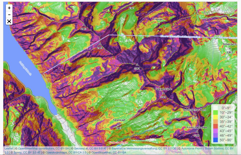
OpenSlopeMap: Slope map by skiers for skiers
Practical service from altruistic hobby cartographers
http://www.openslopemap.org/
Two skiing software developers were dissatisfied with the range of free slope maps available online and created their own map without further ado. The OpenSlopeMap covers Austria, South Tyrol, Bavaria and Slovenia, can be used online and offline and is free of charge. Developer Peter Schnappauf on the OpenSlopeMap project:
mountain knowledge
presented by

Ad
We have therefore started to create our own slope maps using geoinformation software on the basis of high-resolution and freely accessible digital terrain models (so-called DTMs). Depending on the region, the maps are based on different resolutions. For example, the maps for Austria and South Tyrol could be created on the basis of 10m DTM resolutions, while the map of Slovenia or the border regions with Austria/South Tyrol could only be created on 20m DTM resolutions. Unfortunately, the state of Bavaria only makes 50m-DGM data freely available. For countries such as Switzerland, France or parts of Italy, no usable and freely accessible DTMs could be used so far, and accordingly no slope maps could be created for these countries. Should such data become freely available, we would of course also like to cover these areas.
The opinion that DTMs with a 10m resolution are the most suitable basis for creating slope gradient maps for avalanche risk management has largely prevailed. Basically, compromises are always made when creating slope maps. If the underlying DTM is too coarse, the terrain can no longer be depicted realistically. If the underlying resolution is too fine, the terrain will have a very fine resolution. In extreme cases, for example with 1m DTMs, the slope inclinations would be represented very finely, but this does not necessarily correspond to the conditions in winter, as certain slope areas are smoothed out by the snow cover depending on the thickness of the snow cover. Apart from this, the slope inclination maps then become grainy in color and no longer so easy to read and would at the same time suggest a lack of accuracy. For this reason, 10m DGMs are normally a good compromise - knowing full well that in some cases local conditions would require a higher resolution. In the vast majority of applications, 10m data provides the most realistic result overall.
http://www.openslopemap.org/
http://www.openslopemap.org/
At first, we only did the whole thing on a very small scale and created small-scale map sections for each of the activities we had planned. As it would have been a shame if only the two of us had used these maps, we decided last winter to make the maps available to the general public, free of charge and without any commercial interests. So this year I set up the OpenSlopeMap project and have been generating the map for the Eastern Alps over the past few months. You can use the maps in your browser, but you can also download ready-made map files for offline use, e.g. on a smartphone. We wanted to create something meaningful and we would be delighted if the community took up the offer and hopefully many like-minded people will be able to enjoy the map.
Every user of the map should be aware that a map can only ever be a limited view of the real conditions and can therefore never fully represent the actual conditions!
Maps of Switzerland can be found here.
UPDATE 2017
Of course, we weren't lazy over the snow-poor summer months and have implemented a few very interesting new features for the OpenSlopeMap. The most important changes are as follows:
1. we have now been able to create slope gradient maps with a significantly higher slope gradient for the provinces of Tyrol, Salzburg, Vorarlberg and South Tyrol. The slope inclination maps are based on digital terrain models (DTM for short) with an accuracy of 5m. Until now, we could only create data based on DTMs with an accuracy of 10m. So far, these exact 5m-DTMs are only available for the countries mentioned. As soon as other countries follow suit, we will also take them into account accordingly. These are now our "High Resolution"maps.
2. For Austria, South Tyrol and Trentino, we have created slope maps based on DTMs that are based on the 10m data, but which have been recalculated to a higher accuracy (somewhere between 5m and 10m) using the bicubic interpolation method. These are now our "Medium Resolution"maps.
3. As you could already see above, we have now also covered the Trentino with our "Medium Resolution"maps.
4. We have slightly revised the degree classification for slopes over 40°. On the one hand, we have extended the differentiation up to 55°, on the other hand, we have optimized the colour scale for better differentiation.
This article has been automatically translated by DeepL with subsequent editing. If you notice any spelling or grammatical errors or if the translation has lost its meaning, please write an e-mail to the editors.
Show original (German)Comments
Lade...
No comments yet.
-
hTranslated from German.
mountain knowledge
presented by